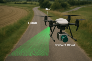
How UAV LiDAR Point Clouds Are Transforming Road Detection and Mapping
Road networks are the lifelines of cities and regional communities. For governments, engineers, and contractors, maintaining these networks safely and efficiently requires reliable spatial data. Traditional photogrammetry and manual surveys … Continue reading How UAV LiDAR Point Clouds Are Transforming Road Detection and Mapping
Copy and paste this URL into your WordPress site to embed
Copy and paste this code into your site to embed