Asset Inventory Mapping with GeoAI: Complete Road Asset Capture Using Laser Scanning and Profiling
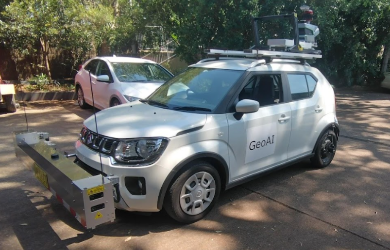
Effective road management and infrastructure planning rely on a precise, up-to-date inventory of every asset within the transport corridor. GeoAI delivers industry-leading asset inventory mapping by leveraging mobile laser scanning, laser profiling, and high-resolution imaging. All equipment is integrated into one powerful survey vehicle. This advanced solution offers a fast, safe, and comprehensive way to digitally capture and manage all roadside features.
What Can GeoAI Record During Asset Inventory Mapping?
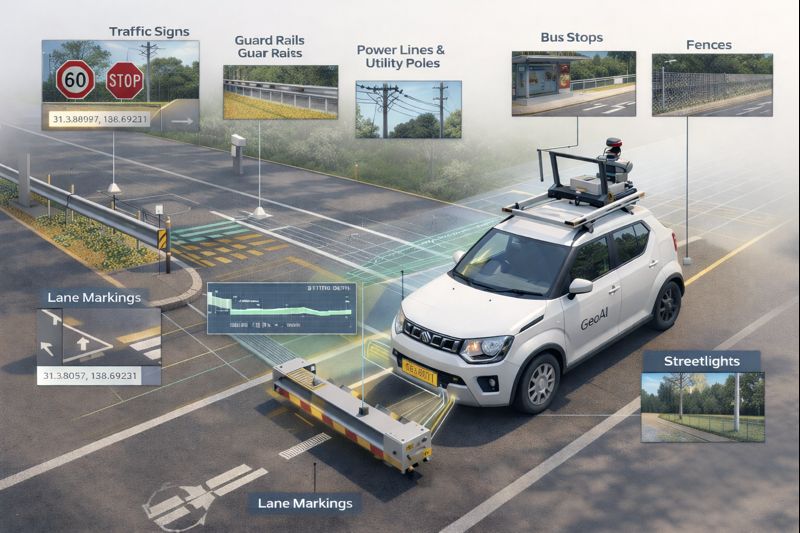
GeoAI’s mobile laser scanner and profiler system, equipped with panoramic and planar cameras, can accurately record:
- Traffic Signs and Signals: Position, orientation, type, and condition of all traffic signage and signal poles.
- Guard Rails, Safety Barriers, and Crash Cushions: Exact length, start and end points, type, and installation details.
- Line Markings and Pavement Markings: Lane lines, edge lines, crosswalks, arrows, turn bays, and any specialty surface markings.
- Bus Stops, Shelters, and Street Furniture: Location, structure type, benches, bins, and accessibility features.
- Utility Poles, Power Lines, and Lighting: Heights, alignment, pole materials, attachments, and overhead clearances.
- Fences, Culverts, Drainage Features, and Retaining Walls: Positions, dimensions, and physical condition.
- Vegetation Encroachment and Clear Zones: Proximity of trees, shrubs, and overhanging branches to the roadway.
- Roadside Objects: Cameras, weather sensors, variable message signs, emergency phones, and more.
Each asset is geo-referenced to centimetre-level accuracy. The data is captured as both 3D LiDAR point clouds and detailed photographic records. GeoAI’s workflow ensures even small, dispersed, or low-profile assets are identified and mapped.
Potential Uses of GeoAI’s Asset Inventory Data
The comprehensive dataset delivered by GeoAI empowers road owners, engineers, and asset managers to:
- Maintain Up-to-Date Asset Registers: Eliminate guesswork and outdated records with a fully digital, easily updateable asset inventory.
- Plan and Prioritize Maintenance: Identify deteriorating signs, damaged guard rails, faded line markings, or obstructed lighting for rapid repair and compliance.
- Support Safety and Compliance Audits: Verify asset presence, placement, and condition against regulatory requirements or standards.
- Feed Asset Management Systems: Seamlessly integrate geospatial asset data into GIS, CAD, or enterprise asset management software.
- Enhance Digital Twin Models: Create a dynamic, living digital twin of the road network. It can support visualisation, scenario planning, and long-term infrastructure investment.
- Facilitate Emergency Response and Planning: Quickly locate critical infrastructure, bus stops, or barriers in case of incidents or route closures.
- Optimize Road Operations: Support projects like road widening, signage upgrades, resurfacing, or corridor redesigns with precise spatial context.
- Enable AI-Powered Analytics: Use the mapped asset data as a baseline for change detection, predictive maintenance, or automated compliance checks in future surveys.
Why GeoAI for Asset Inventory Mapping?
GeoAI combines advanced hardware and AI-powered analytics to deliver faster, richer, and more reliable asset mapping than traditional methods. An efficient survey captures all the details needed for informed decision-making. As a result, this approach can reduce field time, manual effort, and the risk of missed or inaccurate records.
Choose GeoAI for a future-proof approach to road asset management. We deliver not just data, but clarity, insight, and the foundation for smarter infrastructure.
Category List
- 3D Point Cloud
- Artificial Intelligence
- Asset Management
- Digital Twin
- Featured
- Hardware
- Knowledge Graph
- LiDAR
- News
- Site Monitoring
- Vegetation Monitoring
- Virtual Reality
Recent Post
- Asset Inventory Mapping with GeoAI: Complete Road Asset Capture Using Laser Scanning and Profiling
- Mobile Laser Scanner and Laser Profiler: Dual Approach to Road Surface Condition Surveys
- Edge Pavement Detection: Using LiDAR and AI for Road Asset Management
- What is Digital Surface Model (DSM)?
- Happy New Year 2026 from GeoAI
Frequently Asked Question
GeoAI can record a wide range of assets in a single pass, including traffic signs, signals, guard rails, crash barriers, line markings, power lines, utility poles, bus stops, lighting, fences, culverts, drainage features, street furniture, and more.
GeoAI’s integrated mobile laser scanner and GNSS/IMU systems achieve centimeter-level spatial accuracy for all recorded assets. Every asset location is geo-referenced and delivered with engineering-grade precision.
You will receive asset data in industry-standard formats compatible with GIS (e.g., shapefile, GeoJSON), CAD (e.g., DXF, DWG), and digital twin platforms. GeoAI also provides 3D point clouds (LAS/LAZ) and high-resolution photographic documentation.
Yes. The data enables rapid identification of damaged or missing assets, helps plan targeted maintenance, and simplifies compliance audits against road safety and regulatory standards.
GeoAI applies AI algorithms to automatically recognize, classify, and extract asset details from the captured LiDAR and image data. This automation improves survey speed, accuracy, and consistency, even across large and complex networks.
Many road authorities update their asset inventory every 1–2 years or after major construction, but the optimal frequency depends on local regulations, traffic volume, and maintenance cycles. GeoAI’s efficient surveys make regular updates cost-effective and straightforward.