Automated Bus Stop Audit Using Deep Learning Models
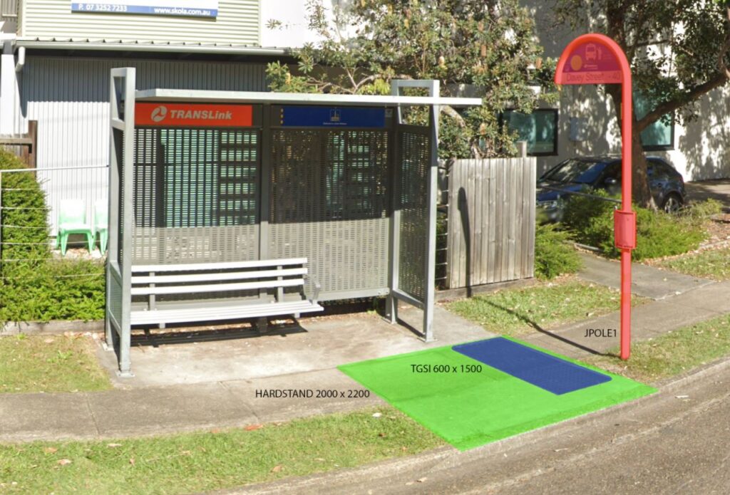
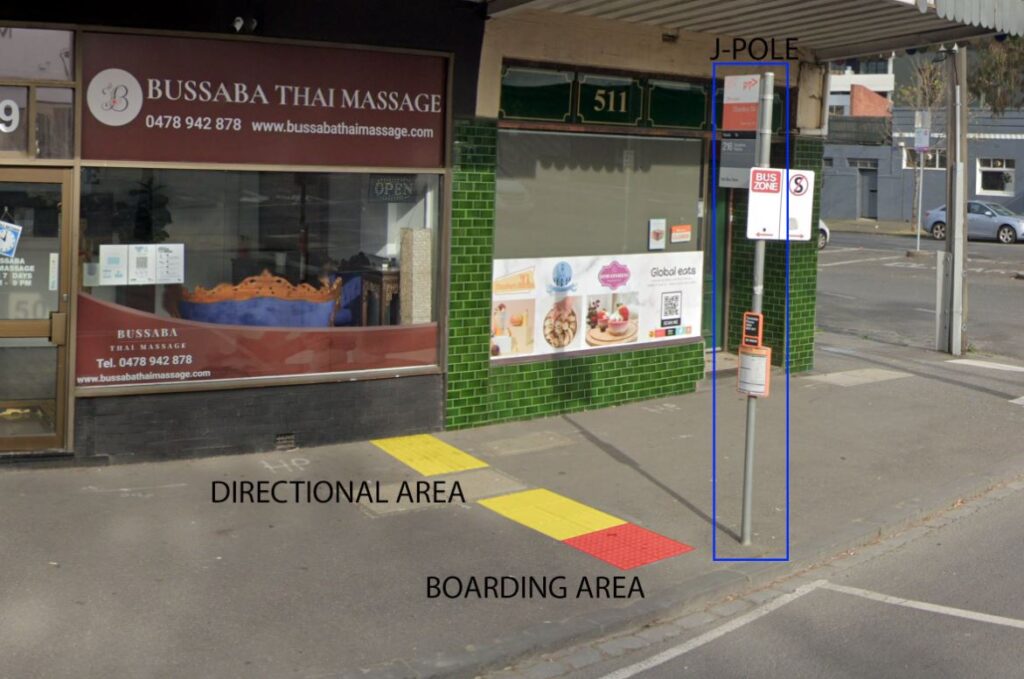
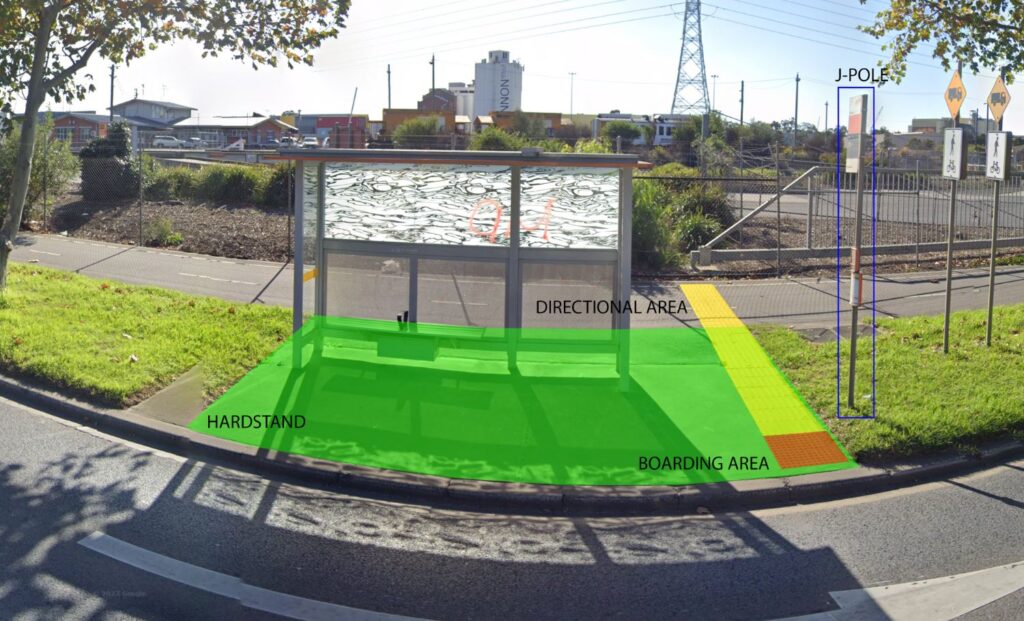
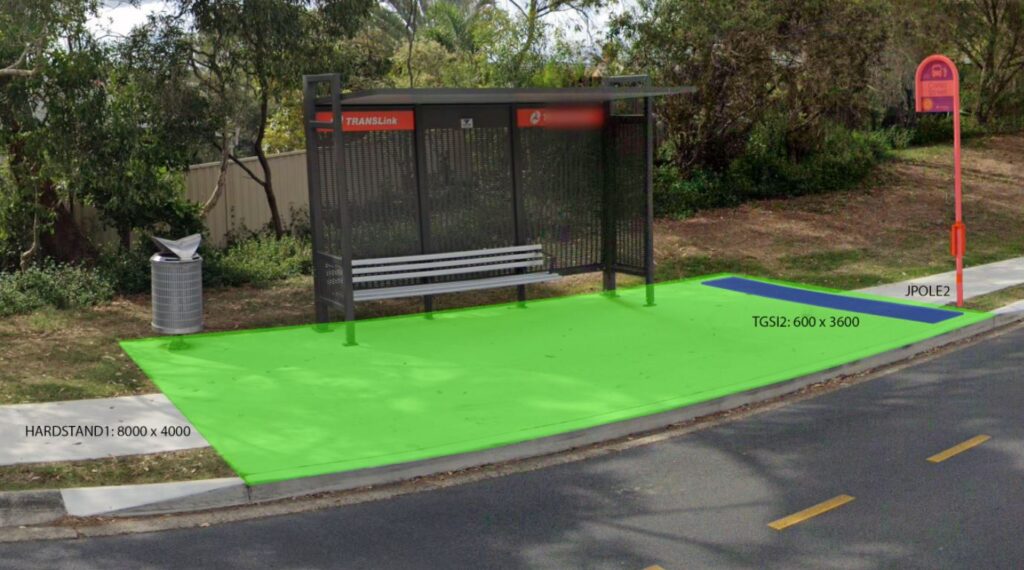
The purpose of these project is to assess the condition of bus stops, identify maintenance requirements, and ensure compliance with relevant standards. The goals for bus stop assessment include the automatic identification of complete tactile ground surface indicators (TGSIs), appropriate signage (J-Pole), and a boarding point. Currently, the audit process is manual and requires a team of 8-10 people working full-time for an entire year. GeoAI aims to automate this process by using deep learning techniques such as Convolutional Neural network and YOLO v8. This model aimed to conduct automatic image segmentation.
Challenge: Manual Bus Stop Audit
The annual audit involves answering multiple questions for each of the thousand bus stops, which is a time-consuming and labour-intensive task. GeoAI sought to automate the audit process to overcome the following challenges:
- Improve safety by reducing the number of people required to physically inspect bus stops.
- Reduce costs associated with manual audits.
- Potentially increase the frequency of audits to ensure timely maintenance and rectification of damaged infrastructure.
- Streamline integration with the Asset holder system for seamless data transfer and reporting.
GeoAI Solution: Deep Learning Model for Object Detection
To address these challenges, GeoAI have been engaged in a pilot project to develop and implement an automated solution using advanced technologies. The proposed solution involved three levels of data capture, including image-based capture, LiDAR (Light Detection and Ranging) detection, and mobile laser scanning.
1. Object Detection and Semantic Segmentation
The backbone of the proposed solution is a convolutional neural network (CNN) for object detection and semantic segmentation. GeoAI employed CNN-based semantic segmentation algorithms to classify and pinpoint various bus stop components. Such as J-pole, hardstand, and boarding area. Deep learning models, including YOLO v8 and Mask RCNN, are utilised with the intention to achieve high accuracy in object detection
2. Training Deep Learning Model
A custom dataset of images was created following suggested best practices for YOLO v8 models. The dataset included a representative variety of images captured at different times of day, in different seasons and weather conditions, and from different angles and sources. Highest precision of the trained models achieved by conducting an accurate data labeling for image segmentation.
3. Data Capture using Mobile Cameras and LiDAR Technology
Data capture involved mounting cameras on vehicles to capture multiple images of each bus stop from various angles. This approach increased accuracy and allowed for the detection of objects that may not be visible in a single image. GeoAI processes the captured data, including images and LiDAR point clouds, to integrate it into the Asset Owner’s system.
Category List
- 3D Point Cloud
- Artificial Intelligence
- Asset Management
- Digital Twin
- Featured
- Hardware
- Knowledge Graph
- LiDAR
- News
- Site Monitoring
- Vegetation Monitoring
- Virtual Reality
Recent Post
- Scan-to-BIM Workflow Explained: From LiDAR Point Cloud to BIM Model
- As-Built Drawing Survey Sydney: LiDAR Verification for Construction Projects
- Digital Twin for Construction Projects – How LiDAR Powers Real-Time Site Models
- Road Asset Management Sydney
- Pavement Condition Survey: AI-Powered Road Assessment for Local Councils
Overall, GeoAI propose solution by combining image analysis, LiDAR technology, and deep learning models to automate the bus stop audit process, detect and measure various features, and integrate seamlessly with the Asset Owners system. With the aim to improve safety, reduce costs, potentially increase the frequency of audits, and streamline data management and reporting.