Digital Twin in Construction
GeoAI has just launched a groundbreaking new viewer for 3D Digital Twin in construction projects! This innovative tool is designed to revolutionize the way construction professionals manage and visualize their projects. In this article, explore the capabilities of GeoAI’s new viewer and discover how it can bring benefits to your construction project.
What is a Digital Twin in Construction?
A Digital Twin in construction is a highly detailed virtual replica of a physical construction site. We create the digital twin by using real-time data and advanced modeling techniques. This digital model allows stakeholders to visualize, monitor, and analyze every aspect of a project, especially in construction phase.
How GeoAI Create the digital twin in Construction?
GeoAI carefully crafts 3D digital twins for construction projects using advanced tools and expert knowledge. The process begins with data acquisition by certified surveyors who utilize drone-based LiDAR, ground-based LiDAR, high-resolution cameras, and 360-degree cameras to capture every detail of the site.
Next, GeoAI engineers process this data, employing photogrammetry to reconstruct accurate 2D and 3D models of the project. Once the reconstruction is complete, we upload the digital twin data to GeoAI’s viewer website. The web-based feature makes the data becomes easily accessible to all stakeholders.
The entire process, from data acquisition to making the digital twin available online, takes just 3 to 4 hours, ensuring real-time updates for your project. Complete step-by step process can be seen here.
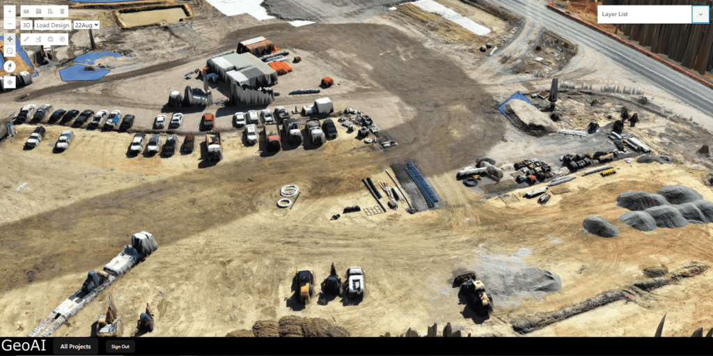
Capabilities of GeoAI 3D Digital Twin Viewer
GeoAI develops a new viewer for 3D Digital Twin in construction with some features that enhance the management and visualization of construction projects:
Real-Time Data Integration
The viewer seamlessly integrates real-time data from drone and mobile laser scanner that provide a live and accurate representation of the construction site. The result of the visualization is accurate into centimeter level. This allows project managers and stakeholders to monitor progress, detect issues early, and make data-driven decisions.
High-Resolution 3D and 2D Visualization
The viewer offers both high-resolution 3D and 2D models. It enable users to explore the construction site in detail from multiple perspectives. Users also can switch between different dates for each dataset. This functionality is invaluable for identifying changes over time. It helps users to easily compare and understand the differences between scans from various dates.
2D Format: In a 2D format, objects are represented in two dimensions—width (X-axis) and height (Y-axis)—appearing as flat shapes with no depth, viewed from a single perspective. We can select layers to manage the order and visibility of objects and information in both 2D and 3D format.
3D Format: In a 3D format, objects are represented with width (X-axis), height (Y-axis), and depth (Z-axis). It gives them volume and allows them to be viewed from multiple perspectives.
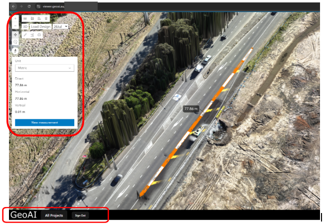
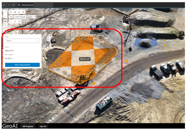
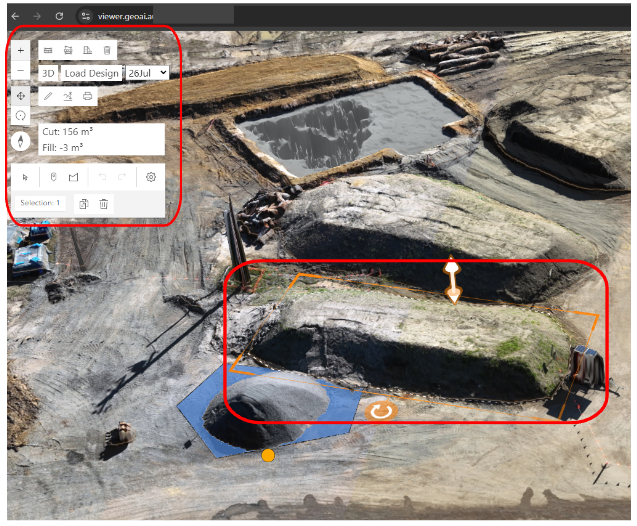
Distance, Area, and Volume Measurement Tools
Equipped with powerful measurement tools, the viewer allows users to measure distances, areas, and volumes directly within the model. These tools are invaluable for precise planning and assessment, ensuring accuracy in project execution.
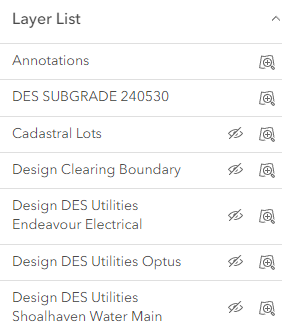
Layer Visualization
The viewer’s layer visualization feature allows users to toggle different layers on and off, providing the ability to focus on specific aspects of the construction project, such as structural elements, utilities, or topography.
Layer list feature displays a list of available layers, each with a ‘visibility’ button, represented by an eye icon. Users can easily toggle the visibility of each layer by clicking this button. When user click the eye icon, the corresponding layer is either displayed on the map or hidden from view.
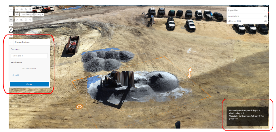
Annotation Tool
Users can directly add annotations to the model to mark important points or provide additional information. The viewer includes built-in collaboration tools that allow team members to share insights, discuss issues, and coordinate efforts directly within the platform. Users can put comments and upload a specific document together with the comment. This fosters better communication and ensures that everyone is on the same page.
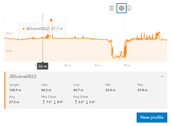
Elevation Profile Calculation
This tool allows users to know the elevation profile to understand the vertical changes across the specific area examined. The elevation data resulting from this feature is based on the WGS84 (World Geodetic System 1984) standard. The WGS84 is a global geodetic reference system used for mapping and navigation, providing a consistent framework for representing geographic locations. It defines the shape and size of the Earth using an ellipsoidal model, with coordinates based on latitude, longitude, and altitude measured relative to mean sea level. As the standard reference system for GPS and many mapping applications, WGS84 ensures accuracy and compatibility across various platforms by establishing a unified coordinate system that allows for precise location determination and spatial analysis.
What is an Elevation Profile? An elevation profile is a graphical representation of the changes in elevation over a specific distance within a scene or terrain. It illustrates how the height varies from point to point, showing peaks, valleys, and flat areas. This profile helps users visualize the terrain’s steepness and elevation changes.
The elevation profile calculation tool further enhances terrain analysis, allowing users to understand inclines, declines, and overall site topography.
Printing Options
The viewer also offers printing options, making it easy to produce physical copies of maps, plans, and other visual data directly from the dashboard.
Vehicle Tracking
The viewer integrates vehicle tracking capabilities, allowing users to monitor the movement of construction vehicles within the site. We put GPS tracker in the vehicle to understand its movement in the construction project. This feature enhances logistics management, resource allocation, and improves the overall efficiency of the project. We keep improving this capability to ensure that stakeholders can get a real-time construction update remotely.
Benefits of Using GeoAI’s Digital Twin in Construction Projects
Enhanced Project Visibility
The viewer provides a comprehensive view of the construction site, allowing stakeholders to track progress, identify issues, and ensure that the project stays on track.
Improved Decision-Making
With real-time data, measurement tools, and advanced analytics at their fingertips, project managers can make more informed decisions, leading to better project outcomes.
Increased Collaboration
The collaboration tools within the viewer promote better communication among team members. With everyone having the same data, it can reduce misunderstandings and ensure that everyone is on the same page.
Cost and Time Savings
By identifying potential issues early, optimizing resource utilization, and effectively managing logistics with vehicle tracking, the viewer helps in reducing project costs and timelines.
Conclusion
GeoAI develops a new 3D Digital Twin viewer to increase the digitalization of construction industry. We provide an unparalleled level of insight and control over construction projects by the assistance of Artificial Intelligence capability. With its extensive features, including measurement tools, layer visualization, vehicle tracking, and printing options, this viewer is an excellent tool for construction professionals. Embrace the future of construction management with GeoAI’s cutting-edge technology.
Category List
- 3D Point Cloud
- Artificial Intelligence
- Asset Management
- Digital Twin
- Featured
- Hardware
- Knowledge Graph
- LiDAR
- News
- Site Monitoring
- Vegetation Monitoring
- Virtual Reality
Recent Post
- Pavement Crack Detection using AI and LiDAR
- Pavement Defect Detection with GeoAI: Harnessing Laser Scanners and Profilers
- Asset Inventory Mapping with GeoAI: Complete Road Asset Capture Using Laser Scanning and Profiling
- Mobile Laser Scanner and Laser Profiler: Dual Approach to Road Surface Condition Surveys
- Edge Pavement Detection: Using LiDAR and AI for Road Asset Management