Geospatial Artificial Intelligence (Geo AI)
Unlock the potential of the digital age with our cutting-edge exploration into Geospatial Artificial Intelligence (Geo AI). Explore the possibilities and applications that Geo AI offers for industries ranging from urban planning and agriculture to disaster management and environmental monitoring.
What is GeoAI?
Geospatial Artificial Intelligence (Geo AI) is the application of geospatial data together with Artificial Intelligence (AI) such as machine learning, data mining, and high performing computer. Artificial Intelligence application becomes a key features as it can process the data faster and provide better insight for decision making.
01. Automate extracting geospatial data using Artificial Intelligence
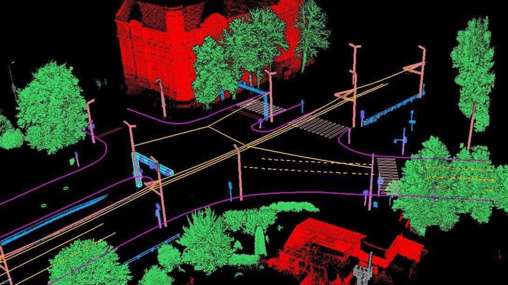
From point clouds or image data, conducting classification, segmentation, and object detection manually can be time consuming. The usage of AI make the extraction of knowledge from spatial data that previously time consumed can become faster and automatic.
02. Perform predictive analysis for better decision making
By using the latest AI algorithm, we can understand the pattern and build model based on the extracted information. As a result, we can generate prediction and help data-based decision making.
Why Geospatial Artificial Intelligence?
GeoAI harnesses the power of advanced Artificial Intelligence (AI) and cutting edge equipment to analyze, interpret, and derive insights from spatial data. It enables a deeper understanding of complex relationships, patterns, and trends within geographic information, providing invaluable solutions for today’s challenges.
Key Features:
- Spatial Data Analysis
- Experience the dynamic synergy between spatial data and advanced AI algorithms, unraveling hidden patterns within geographic information for informed decision-making. Harness the power of spatial data analysis across diverse sectors such as construction, forestry, energy, transportation, and more.
- Latest Technology Equipment
- Stay ahead with state-of-the-art technology equipment, ensuring that your GeoAI solutions are powered by the latest advancements in geospatial technology. We are equipped with UAV, cameras, drone, and mobile laser scanner.
- Cutting-edge Artificial Intelligence
- Embrace the future with cutting-edge artificial intelligence that transforms geospatial data into actionable insights. For example, our GeoAI solutions utilize Convolutional Neural Networks (CNN) and You Only Look Once (YOLO) algorithm to detect project specific element, we use computer vision for concrete spalling detection, and knowledge graph for automatic safety audit.
- Expert Surveyors and Engineers
- Rely on the expertise of our skilled surveyors and engineers who bring a wealth of knowledge to the table. Their proficiency ensures the accuracy and reliability of GeoAI applications, providing you with robust solutions tailored to your specific needs.
- Customized Solutions
- Tailor your GeoAI experience to match your unique requirements. Our customizable solutions allow for flexibility in design and implementation, ensuring that the technology aligns seamlessly with your business objectives and industry demands.
How is Geo AI used?
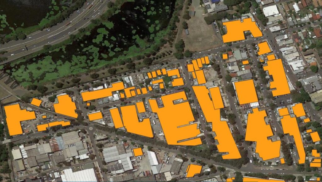
- Urban Planning and Development
- Explore how GeoAI transforms urban planning by optimizing resource allocation, traffic management, energy optimization, and infrastructure development through predictive modeling.
- Precision Vegetation Monitoring
- Delve into the realm of precision vegetation monitoring, where GeoAI enhances tree canopy modelling and automatic vegetation analysis for sustainable practices.
- Structural Health Monitoring
- See how GeoAI plays a pivotal role in detection of concrete spalling in a cooling tower. Leveraging computer vision technology, it enables the identification of cracks. In the realm of asset management, the detection of defects and prediction of maintenance become crucial to prevent structural deterioration and mitigate the risk of a collapse in the built environment.
- Construction Site Monitoring
- In terms of site monitoring, GeoAI leverage the usage of mobile laser scanning, aerial images taken from UAV to get a clear and real time view of your construction project. The stakeholder can stay informed and make decision based on data provided in the digital twin dashboard. Moreover, the application of Virtual Reality will boost the productivity by conducting site monitoring remotely.
Benefits of Geo AI
Experience the transformative benefits of Geospatial Artificial Intelligence, including:
- Enhanced decision-making through precise spatial insights.
- Increased efficiency in resource allocation and utilization.
- Improved risk management and disaster preparedness.
- Sustainable practices in agriculture and environmental conservation.
Stay Updated: Stay updated of the latest developments, case studies, and advancements in GeoAI through our regularly updated blog. Join our community of experts, enthusiasts, and innovators passionate about the intersection of geospatial data and artificial intelligence.
Get Started: Ready to embark on a journey into the future of spatial intelligence? Dive into our resources, explore case studies, and discover how Geospatial Artificial Intelligence is reshaping industries and transforming the way we view and analyze our world.
Embrace the power of Geospatial Artificial Intelligence – where precision meets innovation, and insights shape the future!
Category List
- 3D Point Cloud
- Artificial Intelligence
- Asset Management
- Digital Twin
- Featured
- Hardware
- Knowledge Graph
- LiDAR
- News
- Site Monitoring
- Vegetation Monitoring
- Virtual Reality
Recent Post
- Scan-to-BIM Workflow Explained: From LiDAR Point Cloud to BIM Model
- As-Built Drawing Survey Sydney: LiDAR Verification for Construction Projects
- Digital Twin for Construction Projects – How LiDAR Powers Real-Time Site Models
- Road Asset Management Sydney
- Pavement Condition Survey: AI-Powered Road Assessment for Local Councils