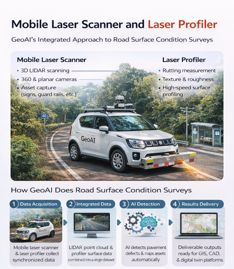
Mobile Laser Scanner and Laser Profiler: Dual Approach to Road Surface Condition Surveys
Modern road networks require accurate, high-speed data collection for effective maintenance and asset management. GeoAI addresses this need by integrating both a mobile laser scanner and a laser profiler into a single, advanced survey solution. This approach delivers a more detailed and reliable result for every road surface condition survey.
Mobile Laser Scanner: Advanced 3D Mapping on the Move
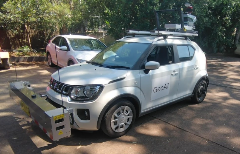
GeoAI deploys a mobile laser scanner system on a survey vehicle. As the vehicle drives along the road, the scanner emits rapid laser pulses in all directions. Each pulse measures the distance to the nearest surface it encounters. It can detect asphalt, curbing, traffic signs, line markings, and even overhead power lines.
This process creates a dense 3D point cloud, often collecting over a million points per second. Every feature along the route is recorded with centimeter-level precision. GeoAI’s mobile laser scanner also integrates:
- 360-degree panoramic cameras: Capture complete, high-resolution images for every segment of road.
- Planar cameras: Provide focused, orthogonal images of the pavement and roadside assets for AI analysis.
- High-precision GNSS/IMU systems: Ensure accurate geolocation, even in GPS-challenged environments like tunnels or dense urban areas.
Key Technical Features
- Scan rate: Up to 1,280,000 points per second
- Range: Up to 300 meters (suitable for wide roads, highways, and corridors)
- Absolute accuracy: Within ±5 centimeters (field-tested)
- Real-time monitoring and quality control during data capture
With this setup, GeoAI can rapidly collect rich geometric and visual information, mapping lanes, intersections, assets, and even subtle surface variations.
Laser Profiler: High-Speed Surface Performance Measurement
Alongside the laser scanner, GeoAI mounts a laser profiler on the same survey vehicle. The profiler uses high-frequency laser lines projected across the pavement to measure the surface profile as the vehicle travels.
What Does the Laser Profiler Measure?
- Rutting: Depth and shape of longitudinal depressions in wheel paths, which indicate wear and drainage issues.
- Texture: Micro- and macro-texture readings, vital for grip and skid resistance analysis.
- Roughness (IRI): International Roughness Index measurements provide a quantifiable assessment of ride quality and pavement smoothness.
The profiler records continuous surface profiles, generating millimeter-scale detail over long distances without requiring lane closures or slowdowns.
Key Technical Features
- Profile accuracy: Sub-millimeter vertical resolution
- Data output: Raw and processed profiles ready for post-processing and pavement condition indexing
Why GeoAI Combines Both: The Technical Advantage
By deploying both the mobile laser scanner and laser profiler together, GeoAI creates a synchronised, multi-dimensional dataset for every survey project.
- Seamless Integration: All systems are time-synchronized, so every LiDAR point, image, and profile measurement shares the same spatial reference.
- AI-Ready Data: The 3D point cloud, panoramic and planar images, and profiler outputs feed directly into GeoAI’s proprietary AI algorithms for automated defect detection.
- Comprehensive Asset Capture: The platform records not only road geometry but also assets such as signs, guard rails, bus stops, line markings, and even power lines. All of that data is geolocated with survey-grade accuracy.
GeoAI’s Road Surface Condition Survey Workflow
- Planning: GeoAI’s team designs a coverage plan based on client needs, road type, and traffic conditions.
- Data Acquisition: A single vehicle, equipped with both the mobile laser scanner and laser profiler, travels the target network at normal traffic speeds.
- On-Site Quality Control: Real-time feedback ensures complete, accurate data collection without unnecessary returns.
- Processing & Analysis: Collected data is processed using robust, automated workflows. AI algorithms identify defects (cracks, rutting, crocodile cracks, pump fines) and asset locations. Technical specialists validate and correct outputs as needed.
- Delivery: GeoAI delivers results in multiple formats such as: 3D point clouds (LAS/LAZ), high-resolution imagery, rutting/roughness profiles, shapefiles, CAD drawings, and GIS-ready asset inventories. Clients receive everything needed for digital twins, asset management, and maintenance planning.
Why Choose GeoAI’s Integrated Solution?
- Complete geometric and surface performance data
- High-speed surveys minimize disruption and reduce field costs
- All data supports AI-powered defect detection and asset mapping
- Flexible output formats for any engineering, GIS, or digital twin platform
- Proven results across highways, local roads, airports, and industrial sites
Category List
- 3D Point Cloud
- Artificial Intelligence
- Asset Management
- Digital Twin
- Featured
- Hardware
- Knowledge Graph
- LiDAR
- News
- Site Monitoring
- Vegetation Monitoring
- Virtual Reality
Recent Post
- Digital Twin Integration for Road Networks Using LiDAR and AI
- Pavement Crack Detection using AI and LiDAR
- Pavement Defect Detection with GeoAI: Harnessing Laser Scanners and Profilers
- Asset Inventory Mapping with GeoAI: Complete Road Asset Capture Using Laser Scanning and Profiling
- Mobile Laser Scanner and Laser Profiler: Dual Approach to Road Surface Condition Surveys
HOW CAN WE HELP YOU?
Message us your questions and contact information.
We’ll get back to you right away!
FREQUENTLY ASKED QUESTION
A mobile laser scanner captures 3D LiDAR data of roads, pavements, curbs, signs, guard rails, line markings, power lines, and other roadside assets. It creates a dense, geo-referenced point cloud with centimeter-level accuracy and can also collect high-resolution images using 360° and planar cameras.
A laser profiler measures pavement surface properties such as: rutting, texture, and roughness. It provides continuous surface profile data at high speeds for detailed pavement condition analysis and performance assessment.
GeoAI’s integrated system detects cracks, crocodile (alligator) cracking, pump fines, rutting, texture anomalies, and surface roughness. AI algorithms analyze both LiDAR and profiler data to automatically locate and classify defects.
GeoAI’s system achieves centimeter-level spatial accuracy in 3D mapping and sub-millimeter vertical accuracy in surface profiling. The integration of GNSS/IMU, LiDAR, and profiling technologies ensures precise, repeatable results.
GeoAI delivers GIS-ready files, 3D point clouds (LAS/LAZ), pavement profile charts, high-resolution images, shapefiles, and CAD files. All outputs support asset management, digital twin modeling, and maintenance planning.