NDWI (Normalized Difference Water Index): Identifying Water Bodies with Remote Sensing
NDWI, or Normalized Difference Water Index, is a widely used remote sensing index that helps detect and monitor water bodies across landscapes. At GeoAI, we use this parameter to support clients in water mapping, flood analysis, land-use monitoring, and environmental assessment through automated, geospatial intelligence platforms.
What Is NDWI?
Normalized Difference Water Index is a satellite-derived index designed to enhance the presence of water features in remotely sensed imagery. Developed by McFeeters in 1996, the index distinguishes open water from land surfaces, vegetation, and built environments using reflectance values from specific spectral bands.
How Is NDWI Calculated?
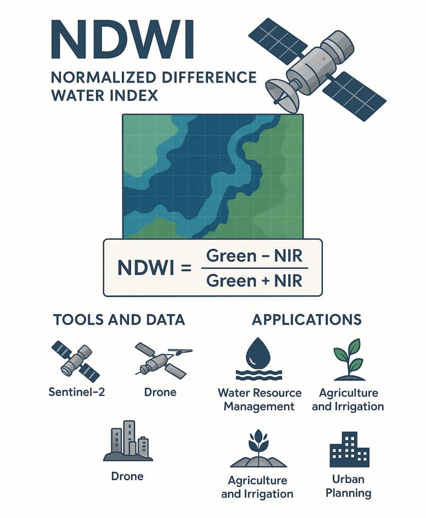
You can calculate NDWI by using the following formula:
NDWI = (Green – NIR) / (Green + NIR)
- Green: Reflectance in the green band (e.g., Band 3 in Landsat 8 or Band 3 in Sentinel-2)
- NIR: Reflectance in the near-infrared band (e.g., Band 5 in Landsat 8 or Band 8 in Sentinel-2)
The result ranges from -1 to +1:Positive values (closer to +1) typically indicate open water. Negative values represent soil, vegetation, or built-up areas. You can see a more detailed result below:
- 0,2 – 1 – Water surface,
- 0.0 – 0,2 – Flooding, humidity,
- -0,3 – 0.0 – Moderate drought, non-aqueous surfaces,
- -1 – -0.3 – Drought, non-aqueous surfaces
Tools and Data Needed to Calculate NDWI
To compute Normalized Difference Water Index, you need multispectral satellite imagery with Green and NIR bands. Common tools and platforms include:
Satellite Data Sources:
- Sentinel-2 (Copernicus) – Free, high-resolution data
- Landsat 8/9 (USGS/NASA) – Historical and current earth observation
- PlanetScope, SkySat – Commercial, very high-resolution imagery
Software & Tools:
- QGIS / ArcGIS – Desktop GIS for manual calculations and map rendering
- Google Earth Engine (GEE) – Cloud-based processing of large datasets
- Python + Raster Libraries (rasterio, NumPy, GDAL) – For automated pipelines
- GeoAI Platform – Cloud-integrated, AI-powered geospatial automation
NDWI Applications Across Industries
Normalized Difference Water Index has broad applications across industries, including:
Water Resource Management
- Detect seasonal or permanent water bodies
- Monitor water availability for agriculture or urban supply
Flood Monitoring
- Assess flood extent in near real time
- Compare pre- and post-event water surface changes
Agriculture and Irrigation
- Evaluate irrigation performance
- Detect waterlogging or drought-prone zones
Urban Planning and Asset Management
- Identify unauthorized water encroachment
- Map surface water near infrastructure
How GeoAI Helps Clients with NDWI Analysis
At GeoAI, we simplify NDWI analysis by offering intelligent, automated platforms tailored for professionals in infrastructure, agriculture, and environmental monitoring.
Automatic NDWI Calculation
We get raw satellite or drone imagery and automatically calculate NDWI using advanced AI and cloud-based processing. There is no need to download or pre process the data manually.
Interactive NDWI Map Online
Our clients gain access to live NDWI maps online through a customized digital twin dashboard. You can explore temporal trends, overlay assets, or receive alerts from the cloud. We can customize the dashboard depending on your need.
You can see the example of our Digital twin dashboard here.
Remote Sensing NDWI Automation
GeoAI integrates with satellite APIs (e.g., Sentinel Hub, Planet API) to fetch up-to-date imagery and process NDWI across your entire site. It is fully automated to easier your business process.
Why Choose GeoAI?
In GeoAI, we combine an advanced Artificial Intelligence with geospatial approaches. As a result, we can provide you with NDWI calculation that can be used for track flooding near assets, monitor seasonal water bodies, or support government compliance. With our expertise, GeoAI gives you:
✅ Scalable NDWI maps in real time
✅ Custom dashboards for water monitoring
✅ Integration with drones, satellites, and sensors
✅ Expert support in remote sensing and geospatial AI
Get Started Today
Want to see how NDWI remote sensing can help your project?
Contact the GeoAI team to request a demo or explore our custom NDWI dashboards for your site.
📧 admin@geoai.au
🌐 geoai.au
📍 34-36 Byrnes St, Botany NSW 2019
Category List
- 3D Point Cloud
- Artificial Intelligence
- Asset Management
- Digital Twin
- Featured
- Hardware
- Knowledge Graph
- LiDAR
- News
- Site Monitoring
- Vegetation Monitoring
- Virtual Reality
Recent Post
- Digital Twin Integration for Road Networks Using LiDAR and AI
- Pavement Crack Detection using AI and LiDAR
- Pavement Defect Detection with GeoAI: Harnessing Laser Scanners and Profilers
- Asset Inventory Mapping with GeoAI: Complete Road Asset Capture Using Laser Scanning and Profiling
- Mobile Laser Scanner and Laser Profiler: Dual Approach to Road Surface Condition Surveys