Soil Adjusted Vegetation Index (SAVI): Definition and Application
What is SAVI?
SAVI, or Soil Adjusted Vegetation Index, is a satellite-derived index designed to monitor vegetation in regions where soil brightness significantly affects vegetation signals. This index is typically used in sparse or arid areas. It enhances the accuracy of vegetation analysis by minimizing the soil background influence. Through this capabilities, it makes SAVI becomes a preferred index in early-stage crop monitoring, dry land ecosystems, and construction site vegetation studies.
How we calculate SAVI?
Soil Adjusted Vegetation Index (SAVI) modifies the Normalized Difference Vegetation Index (NDVI) formula by introducing a soil brightness correction factor (L), commonly set to 0.5. The formula is:
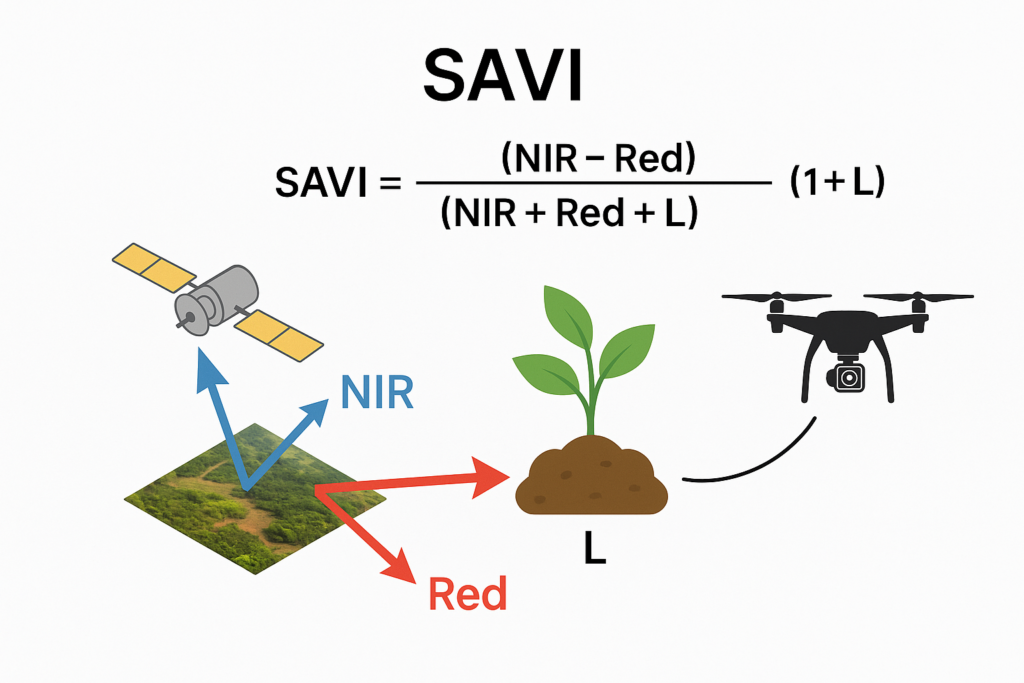
SAVI = [(NIR – Red) / (NIR + Red + L)] × (1 + L)
Where:
- NIR = Near-Infrared reflectance
- Red = Red reflectance
- L = Soil adjustment factor (typically 0.5 for intermediate vegetation cover)
- In Landsat 4-7, SAVI = ((Band 4 – Band 3) / (Band 4 + Band 3 + 0.5)) * (1.5).
- In Landsat 8-9, SAVI = ((Band 5 – Band 4) / (Band 5 + Band 4 + 0.5)) * (1.5).
How Do You Obtain the Data?
To calculate Soil Adjusted Vegetation Index, you’ll need multispectral imagery that includes at least the red and NIR bands. We can obtain this data through:
- Satellite imagery (e.g., Sentinel-2, Landsat)
- Drone-mounted multispectral cameras
- High-resolution aerial surveys
GeoAI helps clients collect, process, and analyze this data using remote sensing workflows and automated vegetation mapping systems.
| Index | Focus | Strengths | Limitations |
| SAVI | Vegetation in sparse/dry areas | Reduces soil background impact | Less suitable in dense canopy |
| NDVI | General vegetation health | Simple, widely used | Affected by soil brightness in sparse areas |
| EVI | Dense forest canopy | Reduces atmospheric and canopy effects | Requires more spectral bands |
| NDWI | Water content in vegetation or water body delineation | Good for irrigation studies | Not focused on soil adjustment |
Application of SAVI
Soil Adjusted Vegetation Index is especially valuable in areas where vegetation is sparse, emerging, or heavily influenced by soil background. Its ability to reduce soil noise makes it an ideal index for a wide range of practical uses in both environmental monitoring and infrastructure-related projects. Some key applications include:
Dryland Agriculture and Rangeland Monitoring
In semi-arid and arid regions, people can use SAVI to track early vegetation growth and assess crop conditions before full canopy cover develops. It helps detect planting success, irrigation performance, and crop stress when traditional indices like NDVI may be too noisy due to exposed soil.
Land Rehabilitation and Reforestation Projects
SAVI enables more accurate monitoring of land recovery efforts, especially during the initial stages of vegetation regrowth where soil visibility is high. This is essential for post-mining sites, reforestation zones, or damaged ecosystems undergoing restoration.
Vegetation Management in Infrastructure Corridors
For construction projects, highways, and utility corridors, we can use SAVI to monitor green buffers, revegetation compliance, and erosion control measures. It helps contractors and regulators assess the success of site rehabilitation over time.
Soil Erosion and Degradation Studies
Since SAVI considers soil brightness, it provides better insight into bare or vulnerable land surfaces. It is useful in detecting areas at risk of erosion, guiding soil conservation practices, or supporting environmental assessments.
Urban Landscaping and Green Infrastructure
In urban environments, SAVI supports precision landscaping and green area tracking in parks, development zones, or newly planted areas. This is important for cities aiming to increase green cover as part of climate resilience strategies.
Monitoring Environmental Offsets and Compliance
SAVI helps companies track vegetation targets required for regulatory offsets or environmental permits, especially in early-stage monitoring where full canopy has not yet developed.
Disaster Response and Recovery
Post-fire or post-flood landscapes can be assessed using SAVI to determine vegetation regrowth progress and to identify areas requiring reseeding or soil stabilization.
By using Soil Adjusted Vegetation Index, organizations can gain more reliable insights in challenging conditions where other indices may fall short. GeoAI integrates SAVI mapping into digital twin dashboards, enabling clear visualization and reporting for vegetation dynamics across time.
How GeoAI Can Help
At GeoAI, we automate SAVI mapping and analysis through drones, satellite data, and AI-powered platforms. Whether you need a custom dashboard to monitor vegetation health or regular SAVI map updates for compliance reporting, we’ve got you covered.
Category List
- 3D Point Cloud
- Artificial Intelligence
- Asset Management
- Digital Twin
- Featured
- Hardware
- Knowledge Graph
- LiDAR
- News
- Site Monitoring
- Vegetation Monitoring
- Virtual Reality
Recent Post
- Pavement Defect Detection with GeoAI: Harnessing Laser Scanners and Profilers
- Asset Inventory Mapping with GeoAI: Complete Road Asset Capture Using Laser Scanning and Profiling
- Mobile Laser Scanner and Laser Profiler: Dual Approach to Road Surface Condition Surveys
- Edge Pavement Detection: Using LiDAR and AI for Road Asset Management
- What is Digital Surface Model (DSM)?
📞 Ready to Get Started?
Let’s discuss how GeoAI can support your project. Contact us today for a free consultation.
📧 admin@geoai.au
🌐 geoai.au
📍 34-36 Byrnes St, Botany NSW 2019