Edge Pavement Detection: Using LiDAR and AI for Road Asset Management
In modern road asset management, accurately identifying the edge of pavements is critical for maintenance, safety, and digital mapping. Traditional survey methods are time-consuming and often lack precision over large areas. Today, LiDAR technology combined with artificial intelligence (AI) offers a powerful solution for edge pavement detection.
What is Edge Pavement Detection?
Edge pavement detection refers to the process of identifying the exact boundary where a paved road surface ends and the shoulder or verge begins. This information is vital for tasks such as road maintenance planning, asset inventory, surface condition analysis, and supporting autonomous driving systems.
How Does LiDAR Work for Pavement Edge Detection?
LiDAR (Light Detection and Ranging) uses laser pulses to measure distances to surfaces and generate dense, highly accurate 3D point clouds of the road environment. A LiDAR scanner can be mounted on vehicles, drones, or even handheld devices, capturing millions of elevation points every second as it travels along the road.
The main advantages of using LiDAR include:
- High spatial accuracy (often within centimeters)
- Ability to scan long stretches of road quickly
- Effective performance in various lighting conditions
How Do We Capture Road Edge Information?
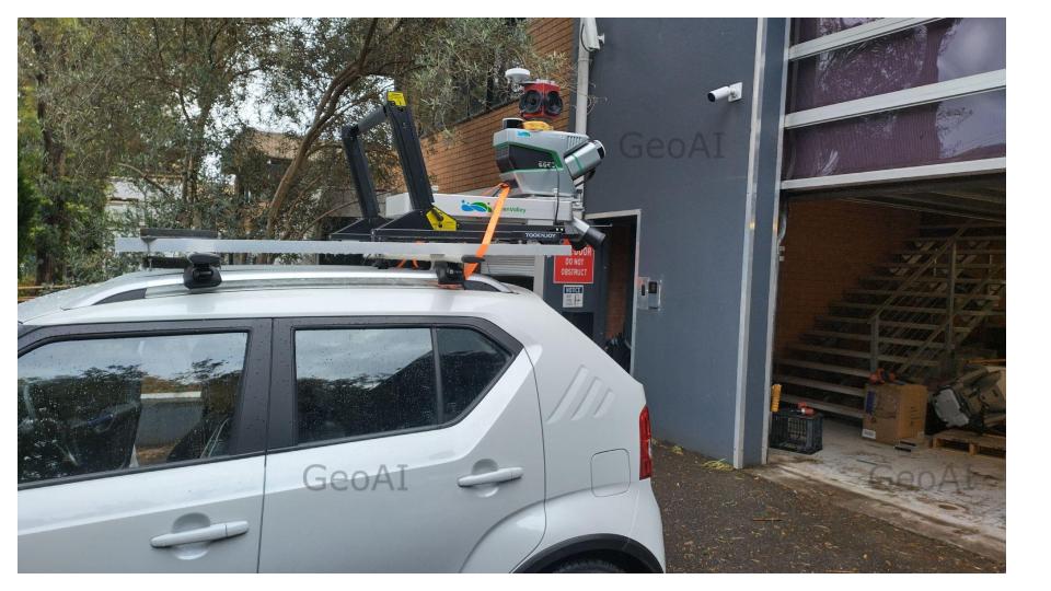
The first step in edge pavement detection is accurate data collection. For this, we use a mobile laser scanner. A LiDAR sensor mounted on a survey vehicle. The process works as follows:
- Mobile LiDAR Survey:
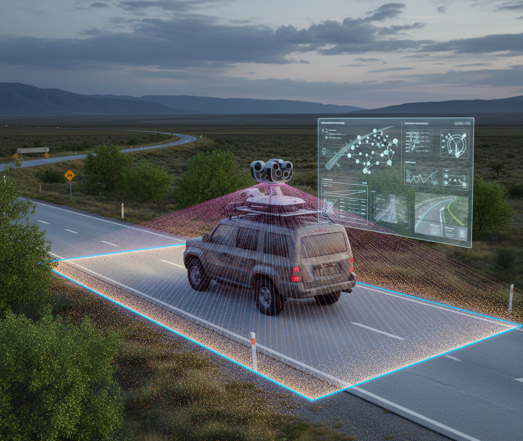
The mobile laser scanner is installed on a vehicle that drives along the road network. As the vehicle moves, the LiDAR system continuously emits laser pulses in all directions, capturing millions of data points every second. - 3D Point Cloud Generation:
Each laser pulse bounces off surfaces like pavement, curbs, road shoulders, and roadside objects, recording their exact positions in three dimensions. The result is a dense and highly accurate 3D point cloud that represents the real-world shape and features of the road corridor. - Comprehensive Coverage:
The mobile LiDAR setup allows for rapid, efficient surveying of long road sections, collecting detailed surface data without disrupting traffic or requiring lane closures. The method works in various lighting and weather conditions, day or night.
Once the data acquisition is complete, the point cloud is ready for AI-powered processing.
The Role of AI in Pavement Edge Detection
Processing LiDAR data manually is not practical for large-scale road networks. This is where AI steps in. Advanced algorithms, often based on machine learning or deep learning, analyze the LiDAR point cloud to automatically detect the pavement’s edge.
The typical workflow includes:
- Ground Extraction: AI filters the point cloud to identify the road surface.
- Feature Segmentation: The algorithm detects sudden changes in elevation or surface texture, which often indicate the edge of the pavement, curb, or gutter.
- Edge Classification: AI distinguishes between true pavement edges and other features like vegetation or road markings.
- Output Generation: The final edge lines are exported as GIS or CAD data for further analysis or asset management.
Why Use LiDAR and AI for Edge Pavement Detection?
- Efficiency: Automated processing allows for rapid surveying and analysis over large areas.
- Consistency: AI algorithms provide uniform results, reducing human error and subjective judgment.
- Detail: LiDAR’s high point density captures subtle features, enabling detection of narrow pavements, damaged edges, or varying road types.
- Integration: Outputs can be easily imported into GIS, CAD, or asset management platforms for maintenance, design, or digital twin creation.
Real-World Applications
Edge pavement detection using LiDAR and AI benefits:
- Road and highway maintenance planning
- Updating asset inventory and maps
- Monitoring erosion or damage along pavement edges
- Autonomous vehicle navigation and safety systems
- Supporting digital twins of transport infrastructure
GeoAI’s Expertise in Edge Pavement Detection
At GeoAI, we combine state-of-the-art mobile LiDAR scanning with robust AI-powered analysis to deliver fast, accurate edge pavement detection services. Our system captures 3D road environments in detail and processes the data using custom algorithms developed for Australia’s unique road conditions.
We deliver pavement edge data as shapefiles, polylines, or 3D models. The result will be ready for your next engineering, asset management, or digital twin project.
Frequently Asked Question
LiDAR detects pavement edges by sending laser pulses that reflect off the road surface and surroundings. Advanced AI model analyzes the resulting 3D point cloud, identifying sudden elevation or texture changes that signal the boundary between the paved road and its shoulder or verge.
AI automates the detection of pavement edges in massive LiDAR datasets, increasing speed and accuracy. Machine learning algorithms learn to distinguish between actual road boundaries and other features like curbs, vegetation, or markings, reducing human error and ensuring consistent results.
Yes, edge pavement detection is essential for road maintenance planning, identifying deteriorating edges, monitoring shoulder encroachment, and prioritizing repairs. It also improves digital maps, supports autonomous vehicle navigation, and enhances overall road safety.
LiDAR-based edge pavement detection can achieve centimeter-level accuracy, depending on the quality of the sensor and processing algorithms. Modern systems produce highly precise edge data suitable for engineering, asset management, and mapping applications.
Detected pavement edges can be delivered in various formats, including GIS shapefiles, DXF, DWG, or as 3D polylines. These formats integrate easily with asset management systems, CAD design platforms, and digital twin models.
Category List
- 3D Point Cloud
- Artificial Intelligence
- Asset Management
- Digital Twin
- Featured
- Hardware
- Knowledge Graph
- LiDAR
- News
- Site Monitoring
- Vegetation Monitoring
- Virtual Reality
Recent Post
- Pavement Defect Detection with GeoAI: Harnessing Laser Scanners and Profilers
- Asset Inventory Mapping with GeoAI: Complete Road Asset Capture Using Laser Scanning and Profiling
- Mobile Laser Scanner and Laser Profiler: Dual Approach to Road Surface Condition Surveys
- Edge Pavement Detection: Using LiDAR and AI for Road Asset Management
- What is Digital Surface Model (DSM)?