3D Lidar Technology for Real-time Progress Monitoring
The primary objective of undertaking these projects is to implement Real-Time Site Monitoring using 3D LiDAR Technology. Currently, the delayed reporting times of a construction project result in substantial costs. The proposed solution aims to address this issue by providing accurate insights into the ongoing progress of the project. This innovative approach not only reduces the time lag in reporting but also offers efficient way of managing construction activities. By embracing real-time monitoring, we aim to enhance the overall project efficiency and mitigate potential delays associated with delayed reporting.
Challenges for Construction Site Monitoring
Implementing real-time construction monitor reviews can pose several challenges both from technical aspects and managerial aspects. These challenges include:
- Accessibility: Construction site are often large and my have some area that difficult to access
- Technological Integration: Compatibility issues may arise when combining different systems and sensors together
- Data Accuracy and Reliability: Data accuracy taken from manual or automatic process can be different
- Cost of implementation and adoption of new technology: Resistance or reluctance from construction teams to adopt new monitoring technologies can hinder successful implementation. Proper training and awareness are essential.
Category List
- 3D Point Cloud
- Artificial Intelligence
- Asset Management
- Digital Twin
- Featured
- Hardware
- Knowledge Graph
- LiDAR
- News
- Site Monitoring
- Vegetation Monitoring
- Virtual Reality
Recent Post
- Scan-to-BIM Workflow Explained: From LiDAR Point Cloud to BIM Model
- As-Built Drawing Survey Sydney: LiDAR Verification for Construction Projects
- Digital Twin for Construction Projects – How LiDAR Powers Real-Time Site Models
- Road Asset Management Sydney
- Pavement Condition Survey: AI-Powered Road Assessment for Local Councils
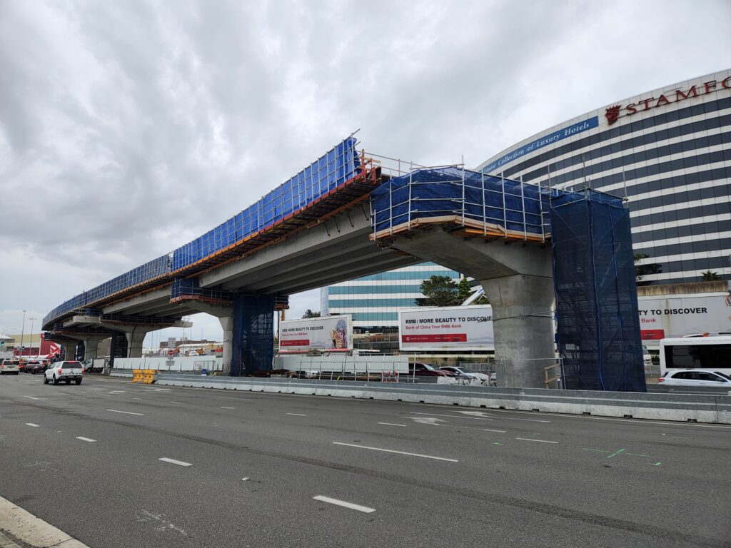
GeoAI Solution using Lidar Technology
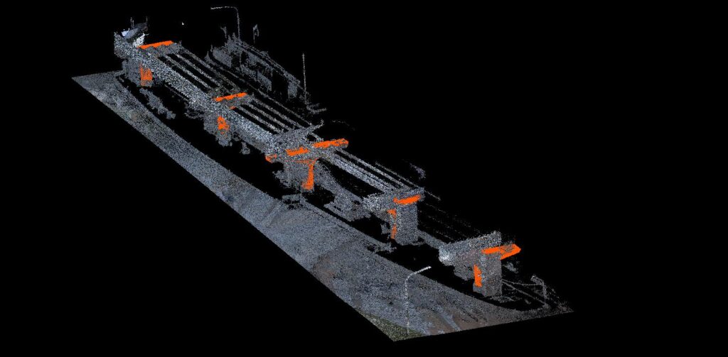
In response to the challenges, GeoAI has strategically incorporated advanced technologies, including LiDAR (Light Detection and Ranging) capture and mobile laser scanning with SLAM (Simultaneous Localisation and Mapping) technology. The point cloud data in this project was taken by using LiBackpack DGC50H.
GeoAI leverages 3D laser scanner for precise and comprehensive data capture. This entails the emission of laser pulses to measure distances, enabling us to create highly detailed and accurate 3D representations of the construction site.
Geometric Feature Extraction
The next step is by using Geometrical Features Extraction to automatically check the progress of construction. The progress was obtained by comparing the as-built point cloud with as-design model. In essence, this framework can be conducted with three integral components: point cloud filtration, features extraction, and progress determination.
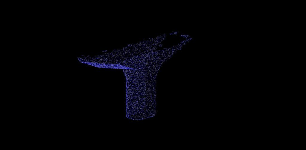
Point Cloud Filtration
GeoAI employs point cloud filtration as a critical step in processing the vast amount of data generated by LiDAR and laser scanning. This involves refining the point cloud data to eliminate noise and irrelevant information, ensuring that the subsequent analysis is based on accurate and pertinent data points.
Features Extraction
Our solution goes beyond basic geometrical features extraction by employing advanced algorithms to identify and extract specific features within the construction site. This includes the automated recognition of structural elements, materials, and changes over time. The result is a detailed and dynamic understanding of the construction environment.
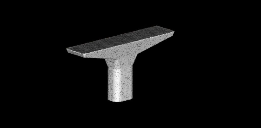
Progress Determination
GeoAI’s approach to progress determination integrates the refined point cloud data and extracted features to provide real-time insights into the construction progress. By analyzing changes and developments within the Segment Digital Twin, our solution facilitates accurate and timely decision-making, allowing project stakeholders to proactively address issues and optimize resource allocation.
In summary, GeoAI’s holistic approach combines cutting-edge technologies, such as LiDAR and mobile laser scanning. This not only addresses the challenges posed by traditional construction monitoring but also provides a comprehensive solution for precise progress determination and informed decision-making throughout the project lifecycle.