Photogrammetry: Method, Benefit, and Application
What is Photogrammetry?
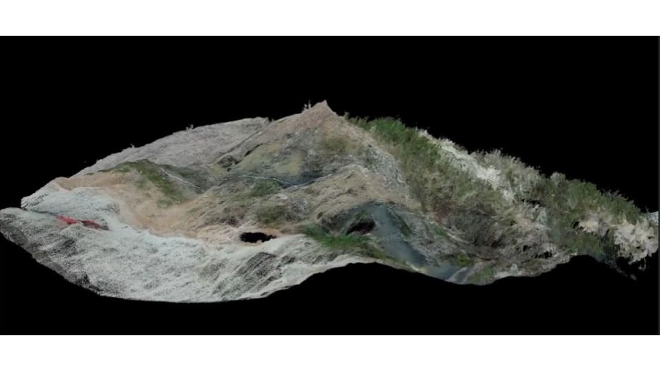
Photogrammetry is a technology to making measurements of an object by collecting various images. By analyzing the geometric properties of multiple images of the same subject, photogrammetry software can reconstruct the 3D structure of the scene with remarkable precision. This process involves identifying common points, known as “tie points,” in the overlapping images and using them to calculate the spatial relationships between different elements in the scene. As a result, we can generate a 3D point cloud data of the physical object.
Photogrammetry is revolutionizing the way we perceive and interact with our surroundings. This cutting-edge technology allows us to capture the world in stunning detail, creating accurate 3D models from ordinary photographs. Company can take benefit by using the 3D model to assist in understanding the object, monitoring, and conduct simulation for upcoming improvement.
When it comes to measuring relatively small objects like our cars, employing traditional methods with a standard ruler is straightforward. Similarly, for buildings, utilizing a tape measure or inclinometer can still suffice, although with some more effort. However, when tackling vast infrastructure projects like airports or extensive mountainous terrains, relying solely on traditional methods becomes impractical. In such cases, photogrammetry and LiDAR technologies emerge as indispensable solutions.
How does Photogrammetry Work?
The process typically involves several key steps:
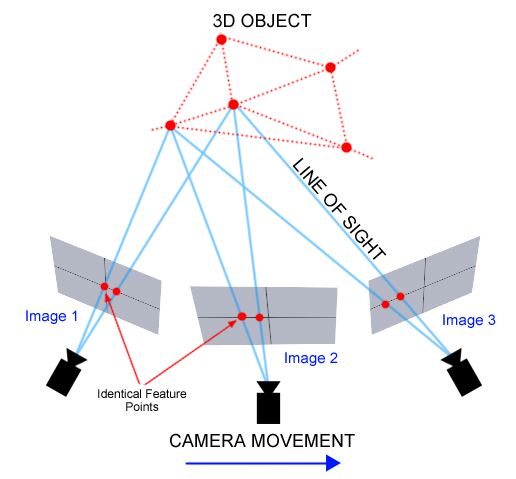
Image Acquisition: We capture high-quality photographs of the subject from different angles using specialized cameras. The data can be in the format of RGB images, aerial images, multispectral images, thermal images, 360 camera images, fisheye images and videos. The camera can be mounted in a drone to generate aerial images for a large area of object. We also can use close-range photogrammetry by use handheld/tripod camera for a smaller object.
Image Processing: We process the acquired images using specialized software, which analyzes the images to identify common features and calculate their spatial positions. The basic principle is by stitching overlapping photographs into 2D mozaic. The position of the camera can be used to estimates x, y, and z coordinates for each pixel of the image.
Source: https://thehaskinssociety.wildapricot.org/photogrammetry
Point Cloud Generation: Based on the x, y, z, coordinate, we generate a dense point cloud based on the identified tie points. As a result, it can represents the 3D structure / 3D point cloud of the scene. This method also known as Structure form Motion (SfM).
Surface Reconstruction: In addition to the point cloud, we can create a detailed surface mesh. It can accurately capturing the shape, colour, and texture of the object. It will make our 3D model becomes more realistic and give more semantic information.
Model Refinement: The generated model may undergo further refinement to improve accuracy and remove any artifacts or inconsistencies.
Output: The final output of this process is a high-fidelity 3D point cloud. We can use the final output of this process to view, manipulate, and conduct simulations using various software tools.
Types of Photogrammetry
We usually use two types of photogrammetry for current projects.
Aerial photogrammetry which utilising aircraft vehicle to take aerial photo and turned into 3D model. This type of data usually used to make a digital terrain or topographic maps of a large area. Aerial vehicle such as drones made the data acquisition becomes faster and easier especially for an area that is not possible to be taken from ground or using traditional surveying method.
Close-range photogrammetry which utilising handheld camera or tripod from a close distance to the object. This type of technology usually used to make a digital model of a small object.
How to Benefit from Photogrammetry?
Photogrammetry offers numerous benefits, including:
- Accuracy: Photogrammetry can achieve sub-centimeter accuracy, making it suitable for applications requiring precise measurements.
- Cost-Effectiveness: Compared to traditional methods of 3D modeling, photogrammetry is often more cost-effective, as it utilizes readily available photography equipment and software.
- Efficiency: With advancements in automation and processing algorithms, photogrammetry allows for the rapid generation of detailed 3D models from large datasets of images.
- Non-Destructive: This technology enables the creation of 3D models without the need for physical contact with the subject, making it ideal for preserving delicate or inaccessible objects.
Application of Photogrammetry
Photogrammetry finds applications across various industries and fields, including:
- Architecture and Construction: Photogrammetry is used for creating detailed 3D models of buildings, construction sites, and architectural landmarks, facilitating design, planning, and documentation processes.
- Archeology and Cultural Heritage: This technology plays a crucial role in documenting and preserving archaeological sites, artifacts, and cultural heritage monuments. It allows researchers to study and analyze them in virtual environments.
- Geospatial Mapping: This technology is utilized for creating accurate digital elevation models, terrain maps, and orthophotos. They can support applications such as urban planning, land surveying, and environmental monitoring.
- Entertainment and Media: In the entertainment industry, this technology is used for creating lifelike 3D characters, environments, and visual effects in movies, video games, and virtual reality experiences.
- Forensics and Crime Scene Analysis: This technology aids forensic investigators in documenting and analyzing crime scenes. It can capture detailed 3D reconstructions for evidence collection and analysis.
- Industrial Inspection and Asset Management: This technology is employed for inspecting and monitoring industrial equipment, infrastructure, and assets. It also can be used for detecting defects, and assessing structural integrity.
Example of Photogrammetry for Concrete Crack Detection
Problem
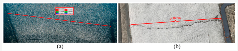
There are many aging infrastructure that need our attention. The collapse of infrastructure can impact the nations both economically and socially. Therefore, the monitoring of infrastructure including concrete cracking become important nowadays. By using close-range photogrammetry, we can accurately detect and quantify defects in infrastructure.
GeoAI Solution
We take several images of a concrete footpath and developing a Convolutional Neural Network (CNN) algorithm to train the data. The method can achieve 0.613 F1 (precision and recall combination) score for minor crack extraction in our pilot case study.
Photogrammetry represents a powerful tool for capturing, analyzing, and visualizing the world in three dimensions. With its ability to generate detailed 3D models from ordinary photographs, photogrammetry is driving innovation across diverse industries. It also opening up new possibilities for research, design, and exploration.
REFERENCE
[1] Guo, Y.; Shen, X.; Linke, J.; Wang, Z.; Barati, K. Quantification of Structural Defects Using Pixel Level Spatial Information from Photogrammetry. Sensors 2023, 23, 5878. https://doi.org/10.3390/s23135878
Category List
- 3D Point Cloud
- Artificial Intelligence
- Asset Management
- Digital Twin
- Featured
- Hardware
- Knowledge Graph
- LiDAR
- News
- Site Monitoring
- Vegetation Monitoring
- Virtual Reality
Recent Post
- Scan-to-BIM Workflow Explained: From LiDAR Point Cloud to BIM Model
- As-Built Drawing Survey Sydney: LiDAR Verification for Construction Projects
- Digital Twin for Construction Projects – How LiDAR Powers Real-Time Site Models
- Road Asset Management Sydney
- Pavement Condition Survey: AI-Powered Road Assessment for Local Councils