Understanding the Urban Heat Island Effect: Causes, Impacts, and Solutions
Urban Heat Island (UHI) effect refers to the phenomenon where urban areas experience higher temperatures than surrounding rural regions. It is a significant environmental concern, driven by urbanization and human activities.
What Is the Urban Heat Island Effect?
UHI occurs because cities have more heat-absorbing materials like concrete, asphalt, and buildings. These surfaces trap heat during the day and release it at night, raising local temperatures. The lack of vegetation and natural cooling factors in urban areas exacerbates this effect.

Causes of the Urban Heat Island Effect
- Heat-Absorbing Surfaces:
- Roads, rooftops, and pavements absorb and retain more heat than natural surfaces.
- Lack of Vegetation:
- Urban areas often lack trees and greenery that provide shade and release cooling moisture.
- Waste Heat:
- Vehicles, industrial processes, and air conditioners release heat, contributing to higher temperatures.
- Dense Building Structures:
- Tall buildings and narrow streets trap heat, reducing airflow and cooling.
- Reduced Water Bodies:
- Urbanization often replaces water bodies that naturally regulate temperatures.
Impacts of the Urban Heat Island Effect
- Health Risks:
- UHI increases heat-related illnesses, such as heat exhaustion and heatstroke, especially during summer.
- Increased Energy Consumption:
- Higher temperatures lead to greater use of air conditioning, raising energy demand and costs.
- Poor Air Quality:
- Warmer temperatures exacerbate air pollution and increase ground-level ozone formation.
- Water Stress:
- Higher evaporation rates affect water resources and increase demand for irrigation.
- Biodiversity Loss:
- UHI affects urban ecosystems, making cities less habitable for plants and animals.
How to Mitigate the Urban Heat Island Effect
- Increase Green Spaces:
- Plant more trees and create parks to provide shade and improve cooling.
- Green Roofs and Walls:
- Install vegetation on rooftops and walls to reduce heat absorption and enhance insulation.
- Cool Roofs and Pavements:
- Use reflective materials that absorb less heat for rooftops and roads.
- Urban Planning:
- Design cities with wider streets, green belts, and water features to improve airflow and cooling.
- Energy-Efficient Buildings:
- Promote energy-efficient building designs to minimize heat emissions.
- Public Awareness:
- Educate communities about UHI and encourage sustainable practices, like reducing vehicle use.
The Role of Technology in Addressing UHI
- Remote Sensing:
- Satellite imagery and drones monitor temperature variations and identify hotspots.
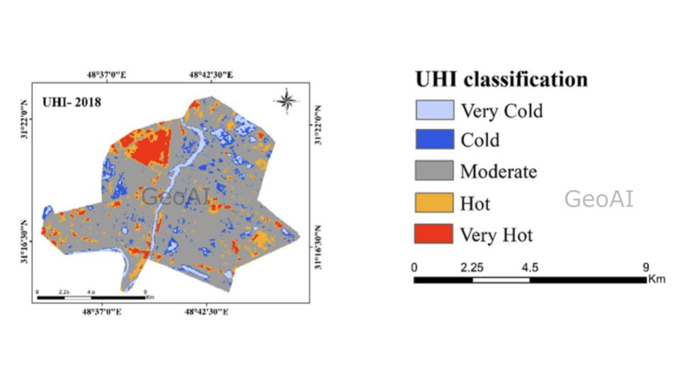
- Land Surface Temperature (LST) and UHI map combination can help to classify and segment areas into different level of heat
- GeoAI Applications:
- GeoAI analyzes UHI patterns and suggests data-driven solutions for urban planning.
- Connected with Land Use and Land Cover (LULC) data, we can see how bare land coincides with very hot UHI.
- Urban Climate Modeling:
- Simulation tools predict how urban designs affect heat distribution, helping planners design cooler cities.
- Real-Time Monitoring:
- IoT devices measure and track urban temperatures, enabling faster responses to heatwaves.
GeoAI’s Role in Combating UHI
GeoAI combines geospatial data and AI to develop innovative solutions for UHI mitigation:
- Heat Mapping:
- GeoAI creates detailed urban heat maps to identify the hottest zones in a city.
- This data can be captured by using thermal data and land surface temperature.
- Predictive Analytics:
- AI predicts future UHI trends based on urban development and climate data.
- Optimized Urban Design:
- GeoAI suggests optimal locations for green spaces, water bodies, and reflective surfaces based on LULC and UHI data
- Policy Support:
- GeoAI provides insights to policymakers for implementing targeted UHI mitigation strategies.
Why Address the Urban Heat Island Effect?
Mitigating UHI is essential for creating sustainable, livable cities. It improves public health, reduces energy consumption, and enhances urban ecosystems. Leveraging GeoAI and sustainable urban design, we can combat UHI and build resilient cities for the future.
Explore how GeoAI can help your city mitigate the Urban Heat Island effect effectively!
Category List
- 3D Point Cloud
- Artificial Intelligence
- Asset Management
- Digital Twin
- Featured
- Hardware
- Knowledge Graph
- LiDAR
- News
- Site Monitoring
- Vegetation Monitoring
- Virtual Reality
Recent Post
- Photogrammetry vs Image Processing: What’s the Difference and How Are They Used?
- Soil Adjusted Vegetation Index (SAVI): Definition and Application
- NDWI (Normalized Difference Water Index): Identifying Water Bodies with Remote Sensing
- Construction Management in the Digital Era: How GeoAI Transforms Projects with Data Analytics and AI
- What is Near Infrared (NIR)?