Automatic Scan to Mesh Technology
Scan-to-mesh technology transforms real-world objects into detailed 3D models using advanced scanning techniques like LiDAR or photogrammetry. The model can be a good foundation to build Digital Twin model for any project. Our Automatic Scan to Mesh Technology offers a seamless workflow for laser scanning data acquisition, processing, and final result generation. Beginning with data acquisition, our advanced scanning systems efficiently capture intricate details with precision. Once the data collection is finish, our expert team handles the processing phase. They will transform raw data into detailed meshes ready for analysis or visualization. The result? High-quality, accurate representations of scanned objects or environments.
Data Acquisition
Data acquisition in our scan to mesh process is revolutionized by cutting-edge laser scanning technology mounted on vehicles. The Mobile Laser Scanning (MLS) technique facilitates rapid data collection across expansive areas. With this innovative approach, we ensure swift and efficient acquisition, enabling us to cover wide ranges while maintaining precision and accuracy. This new LiDAR technology enhances our capability to capture detailed information. It allows us to gather comprehensive data essential for generating high-quality meshes.
Data Processing
Following data acquisition, our dedicated team undertakes the critical phase of in-house data processing to uphold the highest standards of quality and accuracy. By processing the collected data internally, we maintain complete control over the workflow, ensuring meticulous attention to detail at every step. Through rigorous processing techniques and advanced algorithms will be applied into our scan to mesh technology to transform raw data into refined meshes, guaranteeing optimal results that meet the exacting demands of our clients.
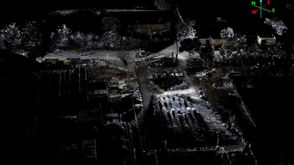
Result
At our service, we pride ourselves on our capabilities to deliver top-notch results swiftly and effectively. Leveraging cutting-edge tools and techniques, we ensure optimal outcomes for our clients, whether it’s in architectural design, industrial inspection, or cultural heritage preservation. With our commitment to excellence and state-of-the-art technology, we guarantee unparalleled service and results that exceed expectations.
Specifications
Our system comes equipped with a LiDAR tilted at a 45-degree angle, along with a high-resolution camera and a Ladybug5+ panoramic camera. This configuration enables rapid acquisition of 3D point cloud data for roads and surrounding elements. It can also plugged in various expansions including DMI, USB 3.0, hard disk, and LAN.
Category List
- 3D Point Cloud
- Artificial Intelligence
- Asset Management
- Digital Twin
- Featured
- Hardware
- Knowledge Graph
- LiDAR
- News
- Site Monitoring
- Vegetation Monitoring
- Virtual Reality
Recent Post
- Photogrammetry vs Image Processing: What’s the Difference and How Are They Used?
- Soil Adjusted Vegetation Index (SAVI): Definition and Application
- NDWI (Normalized Difference Water Index): Identifying Water Bodies with Remote Sensing
- Construction Management in the Digital Era: How GeoAI Transforms Projects with Data Analytics and AI
- What is Near Infrared (NIR)?
Multi Sensor
The incorporation of a multi-channel laser, a GNSS/INS integrated navigation system, and high-resolution cameras facilitates the capture of high-definition point cloud data and imagery data.
Realtime Monitoring
Facilitate real-time monitoring of equipment operational status and display of collected data through the web interface.
Lightweight
Lightweight and compact design. The integrated device weighs around 12.68 kg, ensuring effortless installation and swift transportation.
Application in Industry
- Construction: Scan-to-mesh technology is utilized for precise as-built documentation, construction progress monitoring, and integration with Building Information Modeling (BIM) systems.
- Smart City: In smart city initiatives, scan-to-mesh technology aids in urban planning, infrastructure management, and the creation of digital twins for comprehensive city modeling and analysis.
- Energy and Mining: Within the energy and mining sectors, scan-to-mesh technology is employed for asset monitoring, site mapping, and volumetric calculations.
- AR/VR: Scan-to-mesh technology plays a crucial role in creating immersive augmented reality (AR) and virtual reality (VR) experiences. It can digitizes real-world environments and objects with high fidelity.
- Vegetation Monitoring: In vegetation monitoring and forestry applications, scan-to-mesh technology assists in assessing plant health, measuring biomass, and mapping forested areas accurately. It can assists conservation and management efforts.