Urban Heat Island (UHI): Understanding and Technology for Measurement
What is Urban Heat Island?
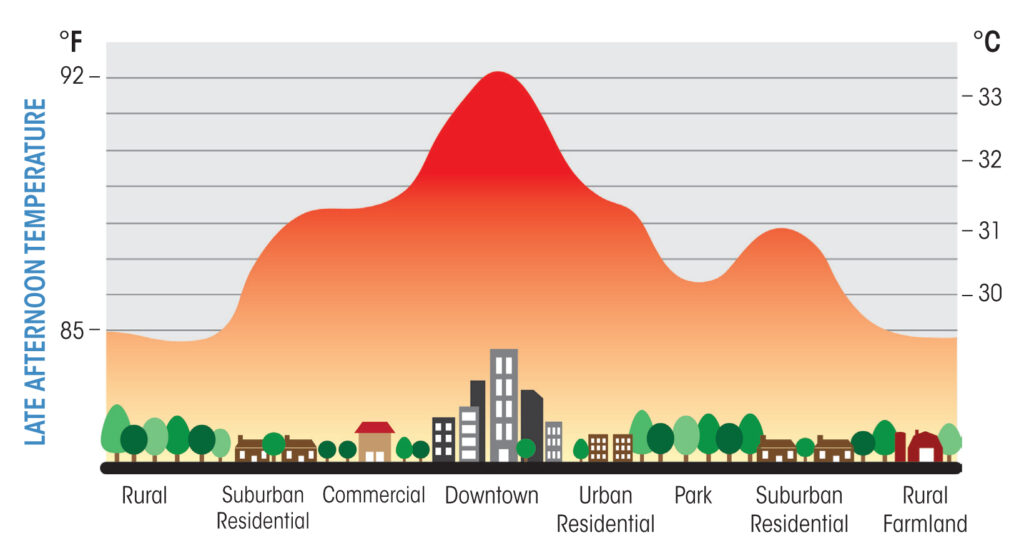
Urban Heat Island (UHI) is a condition where urban areas experience significantly higher temperatures than their rural surroundings. This phenomenon is the impact from human activities, dense infrastructure, and limited vegetation. The Urban Heat Island effect is intensified by various urban design factors that trap and retain heat. Cities and metropolitan areas with concrete buildings, asphalt roads, and limited green spaces absorb and retain more heat from the sun compared to natural landscapes. This effect can increase energy demands for cooling, exacerbate air pollution, and create challenges for urban sustainability. Especially as temperatures continue to rise due to climate change.

Urban Heat Island Effect
The Urban Heat Island (UHI) effect differs between daytime and nighttime due to how materials absorb and release heat. Materials like asphalt, concrete, and metal commonly used in cities have high heat capacity and low albedo. Materials with low albedo absorb more sunlight and release heat slowly, leading to warmer temperatures, especially at night. Additionally, tall buildings in densely populated urban centers contribute to what is known as the “canyon effect,” where buildings block airflow, further limiting heat dissipation.
Cities absorb and slowly release heat, leading to consistently warmer temperatures than rural areas, day and night. At night, the UHI effect becomes more noticeable as urban areas release stored heat. Rural areas cool faster because natural surfaces don’t retain as much heat. Urban temperatures stay higher, keeping cities warmer even after sunset. This retained heat increases air conditioning use, placing stress on energy systems.
Albedo is a measure of how much sunlight (solar radiation) a surface reflects. It is expressed as a percentage or a decimal between 0 and 1. A high albedo means a surface reflects most of the sunlight, while a low albedo means it absorbs more heat.
For example:
Snow and ice have a high albedo, reflecting most sunlight, which keeps them cooler.
Asphalt and concrete have low albedo, absorbing more heat and contributing to the Urban Heat Island effect.
The UHI effect has implications for public health. For example in terms of heat-related illnesses, respiratory issues, and energy demand spikes. Vulnerable populations, including children, older people, and low-income communities, are particularly at risk. This is because they may have limited access to air conditioning or other cooling solutions.
How to Measure Urban Heat Island?
Monitoring UHI requires data collection at different scales, from neighborhood levels to broader metropolitan areas. There are several approaches for measuring UHI:
- Ground-based Temperature Sensors: Fixed weather stations and portable sensors can measure on-the-ground temperatures, providing highly accurate data for specific locations.
- Satellite Imagery: Remote sensing through satellites, such as NASA’s MODIS (Moderate Resolution Imaging Spectroradiometer), captures thermal data that can be analyzed for temperature differences across regions. This approach helps identify UHI patterns on a city-wide scale.
- Aerial Thermal Imaging: Drones and airplanes equipped with thermal cameras capture high-resolution images of temperature variation across urban areas. It provides more localized data than satellites. Local government usually use this data to monitor and reduce the UHI effect.
- Mobile Sensors: Temperature sensors on vehicles or public transportation collect data across different routes. They give a detailed perspective on temperature distribution within cities while transporting from one place to another.
These data sources can be combined to create detailed UHI maps. This maps could provide insights into where and why temperatures are elevated and helping urban planners prioritize mitigation efforts.

Technology to Support Urban Heat Island Monitoring
Advances in technology have significantly enhanced our ability to monitor and analyze UHI. Several emerging technologies aid in understanding UHI patterns and help mitigate their effects:
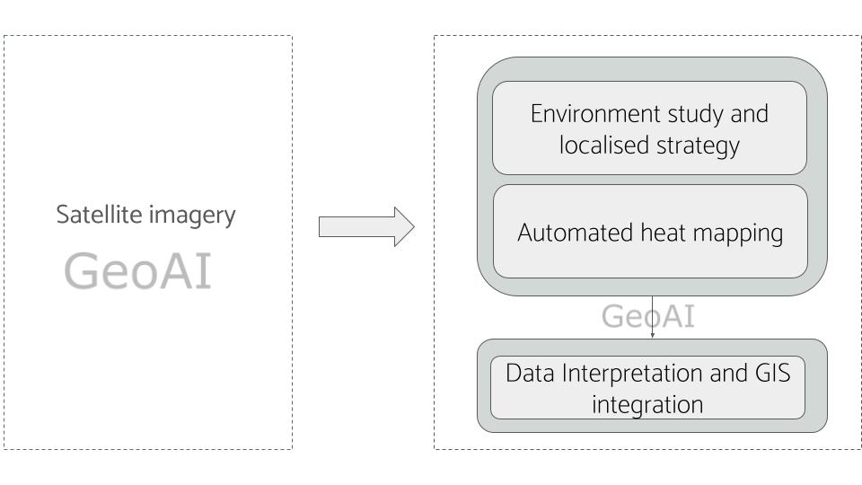
- GeoAI and Machine Learning: GeoAI (Geospatial Artificial Intelligence) combines geographic data with machine learning algorithms to create automated and predictive models of UHI. By analyzing historical and real-time data, GeoAI can help cities model the impact of interventions like green roofs, reflective pavements, and increased tree cover on urban temperature reduction.
- Internet of Things (IoT): IoT-enabled temperature and humidity sensors can create a network of real-time environmental monitoring across cities. This technology allows urban planners to monitor UHI in real time and respond promptly to dangerous heat levels.
- 3D Digital Twin Technology: Digital twins of urban landscapes create a virtual replica of a city that includes temperature profiles and other environmental data. This tool helps urban planners simulate scenarios, test solutions, and assess the effectiveness of heat-mitigating structures before implementation.
- Remote Sensing Platforms: High-resolution satellite and aerial imagery provide comprehensive UHI data over time. The continuous monitoring from platforms like Landsat and Sentinel satellites provides valuable data to track how UHI changes with urban development.
The Urban Heat Island effect is a pressing issue for rapidly growing cities worldwide, posing risks to public health, energy infrastructure, and the environment. Using advanced monitoring technologies like GeoAI, IoT networks, and digital twins, cities can gain a deeper understanding of UHI patterns and make data-driven decisions for climate resilience. Therefore, by integrating sustainable design practices, expanding green spaces, and utilizing reflective materials, cities can work toward reducing UHI effects and creating healthier urban environments for all residents.
Category List
- 3D Point Cloud
- Artificial Intelligence
- Asset Management
- Digital Twin
- Featured
- Hardware
- Knowledge Graph
- LiDAR
- News
- Site Monitoring
- Vegetation Monitoring
- Virtual Reality
Recent Post
- Asset Inventory Mapping with GeoAI: Complete Road Asset Capture Using Laser Scanning and Profiling
- Mobile Laser Scanner and Laser Profiler: Dual Approach to Road Surface Condition Surveys
- Edge Pavement Detection: Using LiDAR and AI for Road Asset Management
- What is Digital Surface Model (DSM)?
- Happy New Year 2026 from GeoAI