What is Digital Elevation Model (DEM)?
A Digital Elevation Model (DEM) is one of the most essential products in geospatial mapping and terrain analysis. It represents the earth’s surface as a continuous grid of elevation values, allowing engineers, planners, and researchers to understand how the ground rises, falls, and changes across an area.
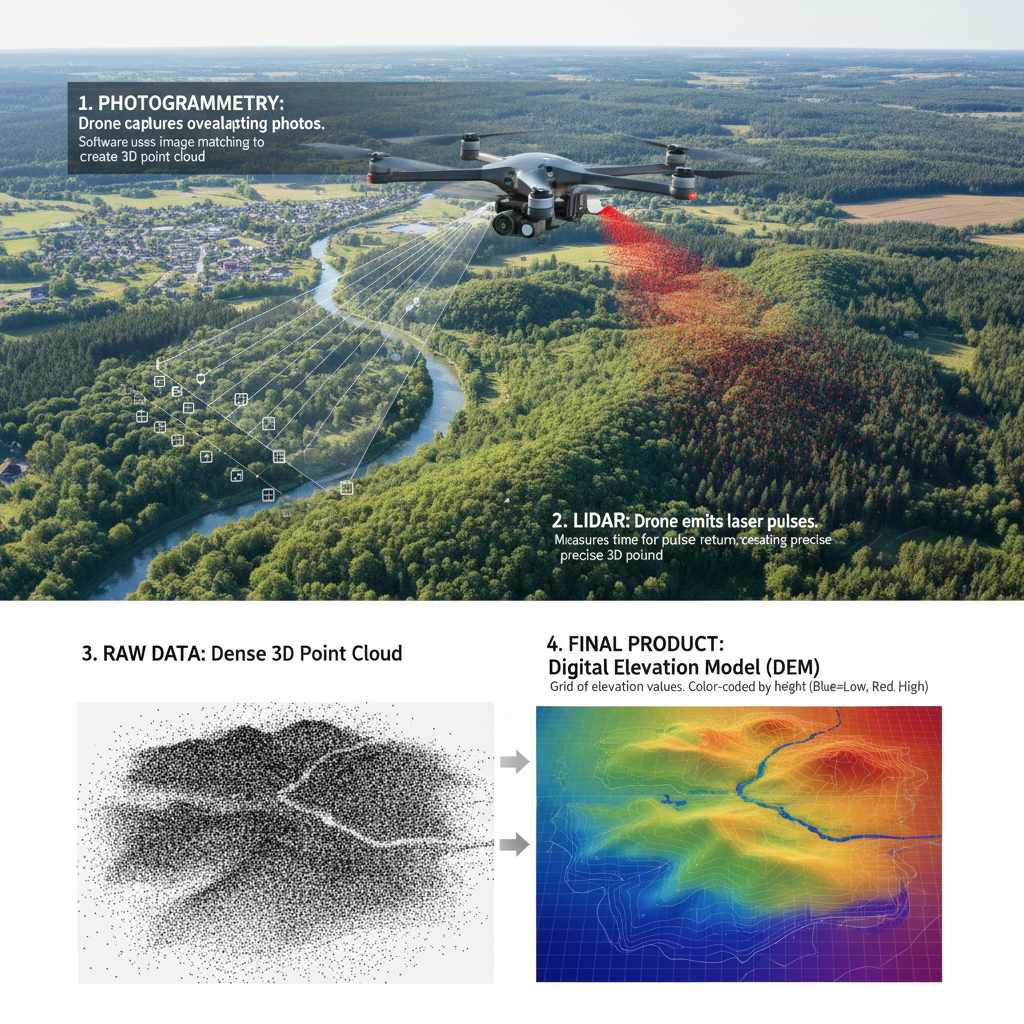
At GeoAI, we work with DEMs every day to support digital twin development, construction monitoring, and asset management. DEMs help visualize real-world topography in 3D and form the foundation of many analytical workflows. It can be generated from drone photogrammetry or LiDAR sensor.
What is a DEM?
A Digital Elevation Model (DEM) is a 3D digital representation of the terrain surface. It is essentially a map of ground elevation without trees, buildings, or other surface objects. Each pixel or grid cell in a DEM contains an elevation value (z-coordinate) corresponding to a specific ground location (x and y).
DEM data allows us to view and analyze terrain in ways that traditional maps cannot. We can measure slope, aspect, drainage patterns, and elevation changes across a landscape, all within a digital environment.
How Do We Get a DEM?
There are several ways to generate a DEM, depending on the scale, accuracy, and technology used.
1. From Drone Photogrammetry
Using a drone equipped with a high-resolution camera, hundreds of overlapping images are captured from above. Photogrammetry software then reconstructs a 3D surface by identifying common points between images. After classifying ground points, we interpolate them to form a DEM that represents the bare earth surface.
2. From LiDAR (Light Detection and Ranging)
LiDAR uses laser pulses to measure distance to the ground, even penetrating through vegetation. By filtering out non-ground points, we can create highly accurate DEMs, often with centimeter-level precision.
3. From Satellite Data
Satellites such as SRTM (Shuttle Radar Topography Mission), ASTER, and TanDEM-X provide global DEMs, though at lower resolution (typically 10–30 meters). These are widely used for regional or national mapping.
4. From Traditional Surveying
For small-scale projects, total stations or GNSS (GPS) surveys can collect elevation points that are later interpolated into a DEM grid.
At GeoAI, we often combine drone photogrammetry and LiDAR to produce high-resolution DEMs suitable for construction and infrastructure management.
Benefits of Using DEM
Accurate Terrain Visualization
DEM allows users to visualize terrain in 3D, providing a clear understanding of ground elevation, slopes, and contours.
Efficient Design and Planning
Engineers use DEMs to plan drainage systems, road alignments, and foundation levels, reducing design errors.
Risk and Hazard Assessment
DEM supports flood simulation, slope stability analysis, and erosion mapping, helping identify potential hazards before they become costly problems.
Volume and Earthwork Calculation
DEM data allows accurate estimation of cut-and-fill volumes in construction and mining projects.
Integration with GIS and Digital Twin Systems
At GeoAI, DEMs serve as a foundational layer in our digital twin platform, where real-world terrain is visualized and linked with project data for continuous monitoring.
Applications of DEM
- Construction and Infrastructure
- Earthwork calculation, slope design, and drainage modeling.
- Monitoring terrain changes caused by excavation or fill.
- Urban and Regional Planning
- Evaluating suitable areas for development based on terrain slope.
- Identifying flood-prone zones for sustainable planning.
- Environmental Management
- Modeling watersheds and runoff patterns.
- Tracking erosion and sedimentation in rivers and catchments.
- Transportation and Road Engineering
- Designing optimal road alignment with minimal cut-and-fill.
- Monitoring slope stability around highways and embankments.
- Renewable Energy
- Assessing solar and wind potential based on terrain orientation and elevation.
- Disaster Management
- Mapping landslide-prone zones and simulating flood inundation scenarios.
How We Use DEM in GeoAI
In GeoAI’s digital twin platform, DEMs are combined with LiDAR, drone photogrammetry, and satellite data to create accurate, up-to-date 3D environments. These models are used for:
- Visualizing construction progress – comparing current site DEMs with design levels.
- Detecting ground deformation – identifying subsidence, erosion, or material accumulation.
- Integrating with AI algorithms – automating slope analysis and hazard prediction.
- Supporting decision-making – providing reliable elevation data for engineering and asset management.
We can export the processed DEMs in GeoTIFF, LAS, or 3D mesh formats and visualized directly in the GeoAI digital twin viewer.
Frequently Asked Question about DEM
A Digital Elevation Model (DEM) is a 3D digital representation of the terrain surface. It is essentially a map of ground elevation without trees, buildings, or other surface objects
A DEM (Digital Elevation Model) represents the bare-earth surface, while a DSM (Digital Surface Model) includes objects like trees and buildings. A DTM (Digital Terrain Model) is a refined version of a DEM, often enhanced with additional terrain features such as breaklines or contours.
A well-calibrated drone photogrammetry DEM can achieve 3–5 cm vertical accuracy when using ground control points or RTK positioning.
Yes, DEMs are essential for flood and drainage modeling. They help simulate water flow and identify low-lying areas vulnerable to inundation.
You can use GIS platforms such as QGIS, ArcGIS, or the GeoAI digital twin viewer to visualize and analyze DEM data in 2D and 3D.
The frequency depends on the project. For construction sites, monthly or milestone updates are ideal. For regional mapping, yearly updates are usually sufficient.
Category List
- 3D Point Cloud
- Artificial Intelligence
- Asset Management
- Digital Twin
- Featured
- Hardware
- Knowledge Graph
- LiDAR
- News
- Site Monitoring
- Vegetation Monitoring
- Virtual Reality
Recent Post
- Digital Twin Integration for Road Networks Using LiDAR and AI
- Pavement Crack Detection using AI and LiDAR
- Pavement Defect Detection with GeoAI: Harnessing Laser Scanners and Profilers
- Asset Inventory Mapping with GeoAI: Complete Road Asset Capture Using Laser Scanning and Profiling
- Mobile Laser Scanner and Laser Profiler: Dual Approach to Road Surface Condition Surveys