What is LiDAR Technology?
Light Detection and Ranging (LiDAR) is a remote sensing method uses laser beams to create a 3D representation of the surveyed environment
LiDAR sometimes known as ‘laser scanning’ or ‘3D scanning’ use eye-safe laser beams to measure variable distances to the Earth. The result of the LiDAR scanning can be used to examine the surface of the surveyed area. It produce an accurate x,y,z measurements. The system can be mounted in aerial vehicle, ground vehicle, or even handheld/backpack for laser mapping application. As a result, LiDAR usage can be a cost-effective alternative of traditional surveying techniques. It can scan a large area in a short time.
The LiDAR system produce 3D point cloud datasets. The dataset can be managed, analyzed, and visualized using different process to get a valuable insight for the stakeholder.
Component of LiDAR Technology
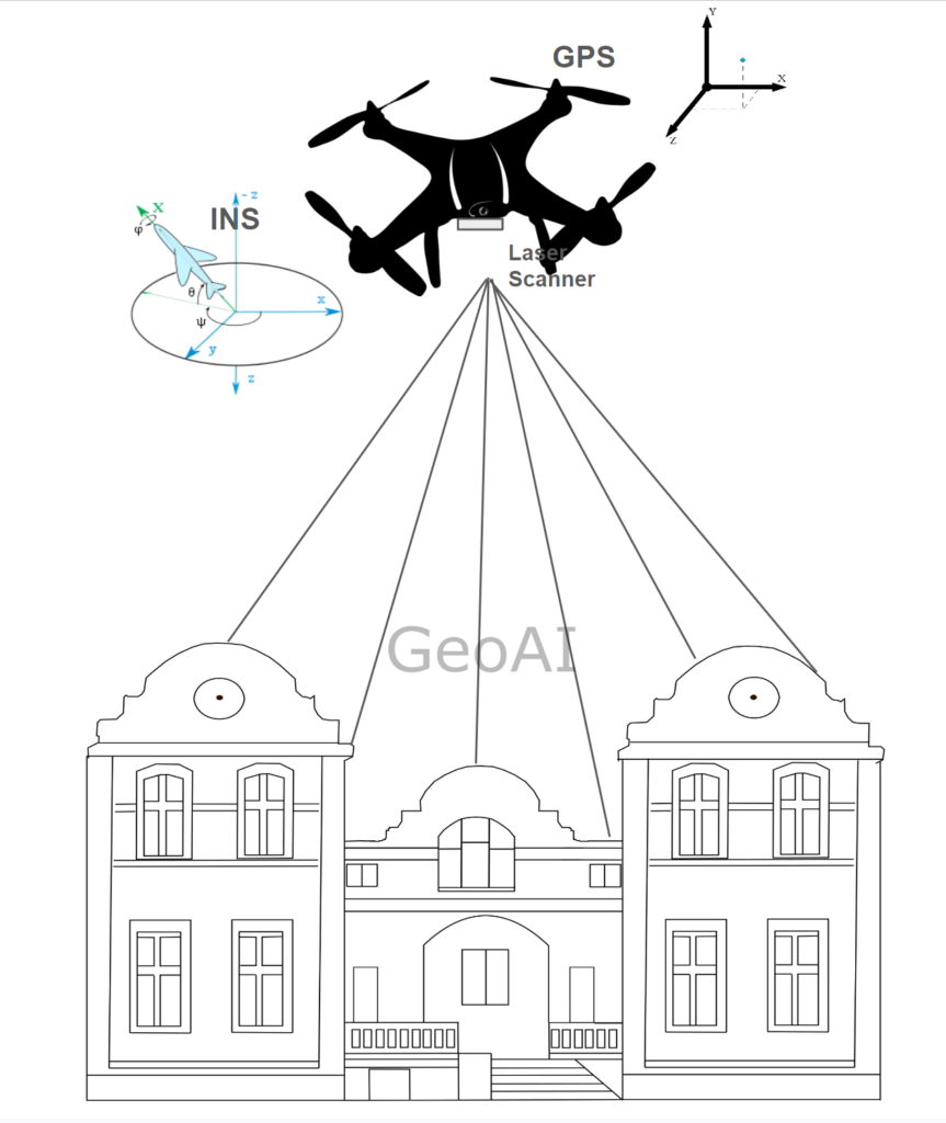
Lidar systems typically consist of a laser scanner, a Global Positioning System (GPS) receiver, and an Inertial Navigation System (INS). Users can mount the LiDAR system on various vehicles and combine it with a camera.
Collection vehicle:
- Aircraft, drone, helicopter
- Car / mobile vehicle
- Tripod / static vehicle
- Backpack
- Hand-held
Laser Scanner:
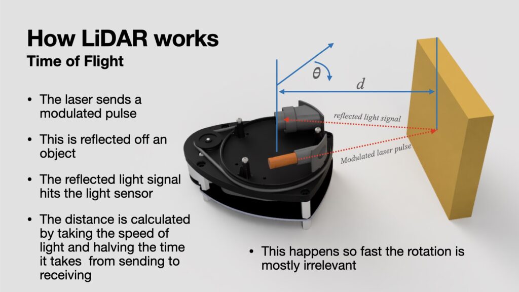
- The laser scanner is the core component of a lidar system responsible for emitting laser pulses and capturing the reflected light.
- It emits rapid laser pulses towards the target area. When these pulses encounter objects or surfaces, some of the light is reflected back to the lidar sensor.
- The laser scanner measures the time it takes for the emitted pulses to travel to the object and back. As a result, it can calculate the distance to the target with high precision.
- By scanning the laser pulses across the area of interest, the laser scanner collects millions of distance measurements per second. Thus, it generates a dense point cloud representation of the terrain or objects within the scanned area.
GPS (Global Positioning System):
- The GPS receiver integrated into the lidar system determines the precise geographic coordinates (latitude, longitude, and altitude) of the lidar platform.
- By receiving signals from multiple satellites orbiting the Earth, the GPS receiver provides real-time positioning information. It ensures accurate georeferencing of the collected LiDAR data.
- Georeferencing with GPS coordinates enables the integration of lidar data with other geospatial datasets, such as aerial imagery or GIS data. It can facilitates various applications such as mapping, surveying, and monitoring.
INS (Inertial navigation System):
- The Inertial Navigation System (INS) measures the roll, pitch, and heading (yaw) of the lidar system.
- It typically consists of gyroscopes and accelerometers to monitor the motion dynamics of the collection vehicle.
By integrating GPS and INS data, lidar systems can accurately georeference the collected point cloud data while correcting for the effects of platform motion. It ensures the reliability and accuracy of the final 3D spatial information.
How LiDAR Technology works?
- Pulsed Laser Emission: The lidar system emits rapid laser pulses towards the target area.
- Reflection and Detection: When the laser beam hits an object, some of the light is reflected back to the lidar sensor.
- Time-of-Flight Calculation: By measuring the time it takes for the laser pulse to travel to the object and back, lidar systems can calculate the distance to the target with high precision.
- Scanning and Data Collection: As the lidar platform moves, its scanner directs the laser pulses across the area of interest, collecting millions of distance measurements per second.
- Data Processing: The collected distance measurements are processed to create detailed 3D maps or models of the terrain, buildings, vegetation, and other features in the scanned area.
Applications of LiDAR Technology
Lidar technology finds applications in various fields including:
- Topographic Mapping: Surveyor uses LiDAR to create high-resolution digital elevation models (DEMs) for geological surveys, floodplain mapping, urban planning, and infrastructure development.
- Forestry and Agriculture: Lidar can assess forest structure, biomass, and health. In agriculture, people use LiDAR for crop monitoring, yield estimation, and precision farming.
- Urban Planning and Infrastructure: Lidar helps in city planning, transportation management, and infrastructure monitoring by providing detailed 3D models of buildings, roads, and utilities.
- Autonomous Vehicles: Lidar plays a crucial role in the development of autonomous vehicles, providing accurate 3D maps of the surroundings for navigation and obstacle detection.
- Archaeology and Cultural Heritage: Lidar enables the discovery and documentation of archaeological sites, cultural heritage sites, and ancient landscapes by revealing hidden features beneath vegetation or terrain.
Category List
- 3D Point Cloud
- Artificial Intelligence
- Asset Management
- Digital Twin
- Featured
- Hardware
- Knowledge Graph
- LiDAR
- News
- Site Monitoring
- Vegetation Monitoring
- Virtual Reality
Recent Post
- Scan-to-BIM Workflow Explained: From LiDAR Point Cloud to BIM Model
- As-Built Drawing Survey Sydney: LiDAR Verification for Construction Projects
- Digital Twin for Construction Projects – How LiDAR Powers Real-Time Site Models
- Road Asset Management Sydney
- Pavement Condition Survey: AI-Powered Road Assessment for Local Councils