What is Digital Surface Model (DSM)?
A digital surface model (DSM) is a three-dimensional map that shows the elevation of everything on the earth’s surface. DSMs include not just the bare ground, but also trees, buildings, bridges, power lines, and other structures. This type of model provides a complete snapshot of the visible landscape at a certain moment in time. Engineers, planners, and researchers rely on DSMs for a wide range of applications, from urban development to environmental monitoring.
How to Produce a Digital Surface Model?
Technical Workflow
To create a digital surface model, you need accurate, dense data. Two main technologies are used: LiDAR and photogrammetry.
- LiDAR Scanning:
A LiDAR system emits thousands to millions of laser pulses per second from a drone, aircraft, vehicle, or tripod. Each pulse hits an object and returns to the sensor. The LiDAR records the distance, creating a dense 3D point cloud. Most LiDARs register not just the ground, but also the tops of trees, roofs, and any object on the surface. By keeping the “first returns,” you get the DSM. - Photogrammetry:
Drones or airplanes take overlapping images of the ground. Specialized software uses these images to calculate the height of every point in the scene. The result is a 3D point cloud or a mesh. This mesh or grid includes everything visible from above such as: canopies, structures, even parked cars.
Once you have the point cloud, you process it to generate a raster (grid) or mesh. The grid values represent the highest object at each location. Software such as LAStools, Global Mapper, Pix4D, or other GIS platforms can handle this process.
Practical Considerations
In the field, surveyors plan flight paths or scanning routes to ensure full coverage and the right resolution for the project’s goals. For cities, a higher density of points is needed to capture sharp edges of buildings. In forests, extra care ensures the tops of the canopy are accurately recorded.
Data cleaning is important. You may need to remove noise (like birds in the air or temporary objects). You also choose the grid size—smaller cells for high-detail city models, larger cells for regional studies.
You can export deliverables in formats like GeoTIFF, LAS/LAZ, or as 3D meshes for visualization and analysis.
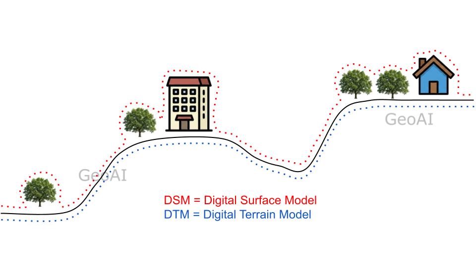
Differences Between DSM, DTM, and DEM
Understanding the difference between these three models is crucial:
DEM (Digital Elevation Model):
This is a general term for any 3D elevation model. In some regions, “DEM” is used for bare-earth models (like DTM). In others, it can refer to either DSM or DTM. Always check the data source.
DSM (Digital Surface Model):
Shows the elevations of everything on the surface. Trees, buildings, vehicles, and the ground are all included. Use DSM when you need to analyze real-world conditions, such as city planning, telecommunications, and solar energy.
DTM (Digital Terrain Model):
Focuses only on the bare earth. All above-ground features are removed. DTM is the best choice for engineering design, hydrology, and earthwork calculations.
Connection with Digital Twin
A digital twin is a virtual replica of a real-world asset, system, or environment. To build a digital twin for a city, infrastructure, or landscape, you need accurate 3D data of the physical world. This is where the digital surface model becomes essential.
- Base Layer: The DSM forms the foundation for 3D city models and digital twins. It provides not only ground levels but also the height and shape of buildings, vegetation, and other structures.
- Visualization: Planners and stakeholders can visualize how new developments will interact with the existing environment using the DSM.
- Simulation: Digital twins often simulate real-world processes, such as flood risk, air flow, or traffic. These simulations require detailed surface data, which comes from DSMs.
- Asset Management: Utilities, municipalities, and facility managers use digital twins to track assets and plan maintenance. The DSM helps pinpoint the location and context of every asset.
By updating DSMs over time using repeat scans or drone flights, we can monitor changes, track construction progress, or observe vegetation growth. As a result, this dynamic capability can improve the capability of a digital twin.
Why Use Digital Surface Models?
A digital surface model unlocks a deeper understanding of the real world. We can:
- Analyze urban density and building heights
- Design communication networks and assess line-of-sight
- Calculate sunlight and shade for solar panels
- Assess risk from floods or natural hazards
- Model and monitor vegetation growth in forests and cities
GeoAI specializes in producing high-quality DSMs using the latest LiDAR and drone technology. Our experts ensure your data is accurate, complete, and ready to support digital twin initiatives or any other project that requires a detailed map of the world above the ground.
Get in Touch
Interested in seeing what a digital surface model can do for your project? Contact GeoAI for a sample dataset or a demonstration. Our team can help you harness the power of DSMs for better decisions and smarter digital twins.
Frequently Asked Question (FAQ)
A digital surface model (DSM) includes all objects on the surface, such as buildings, trees, and vegetation, while a digital terrain model (DTM) represents only the bare ground surface, with all above-ground features removed.
You can create a DSM using LiDAR scanning or aerial/drone photogrammetry. LiDAR captures elevation points by measuring the return time of laser pulses, recording the highest points. Photogrammetry builds 3D models from overlapping images, capturing everything visible from above. Specialized software processes the data into a grid or mesh representing surface elevations.
Digital surface models are widely used in urban planning, telecommunications (line-of-sight analysis), solar panel placement, flood risk modeling, forestry analysis, and 3D city modeling. DSMs provide detailed elevation information about both natural and built environments.
Common file formats for DSMs include GeoTIFF (raster grid), LAS/LAZ (point cloud), ASCII XYZ, and sometimes CAD-compatible files like DXF. The format depends on the data source and the software you use for analysis or visualization.
DSM accuracy depends on the data collection method, flight altitude (for aerial surveys), point density, and surface complexity. Modern LiDAR or drone-derived DSMs typically achieve vertical accuracy of 5–20 centimeters, but quality can vary based on the environment and equipment used.
Category List
- 3D Point Cloud
- Artificial Intelligence
- Asset Management
- Digital Twin
- Featured
- Hardware
- Knowledge Graph
- LiDAR
- News
- Site Monitoring
- Vegetation Monitoring
- Virtual Reality
Recent Post
- Pavement Defect Detection with GeoAI: Harnessing Laser Scanners and Profilers
- Asset Inventory Mapping with GeoAI: Complete Road Asset Capture Using Laser Scanning and Profiling
- Mobile Laser Scanner and Laser Profiler: Dual Approach to Road Surface Condition Surveys
- Edge Pavement Detection: Using LiDAR and AI for Road Asset Management
- What is Digital Surface Model (DSM)?