New Digital Twin Platform
We are thrilled to present our latest innovation: the revolutionary Digital Twin Platform! Through the seamless integration of multi-SLAM (Simultaneous Localization And Mapping) and advanced 3D Gaussian Splatting (3DGS) techniques, we bring you a cutting-edge solution for creating highly realistic and swiftly generated 3D digital representations of your projects.
Digital Twin Platform
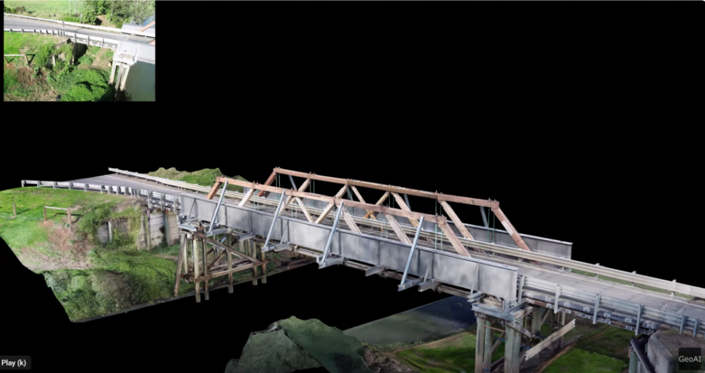
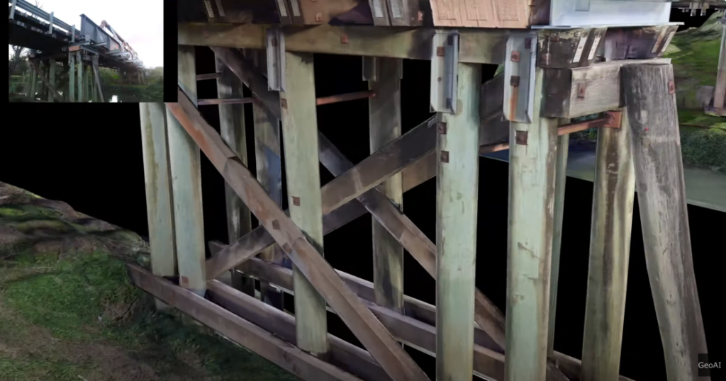
Imagine having a digital clone of a real-life object or system that you can interact with virtually— that’s essentially what a new digital twin platform offers. This technology is accessible through various platforms like web-based applications, mobile apps, and software such as Unity or Unreal Engine. Whether you’re using your computer, smartphone, or specialized software, the digital twin gives you a detailed and dynamic representation of physical objects or processes.
For instance, you could have a digital twin of a building, a piece of machinery, or even an entire city infrastructure. This twin isn’t just a static model; it’s constantly updated with real-time data, allowing you to monitor and analyze its behavior, simulate different scenarios, and even test out changes without affecting the real thing. It’s like having a virtual laboratory where you can experiment and innovate, making it a powerful tool across various industries, from architecture and engineering to manufacturing and beyond.
Key Features of the Digital Twin Platform
Precise Measurement Tools
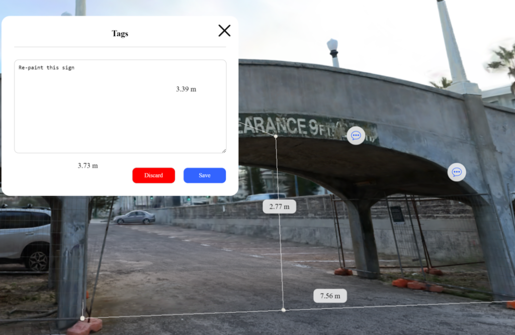
Our platform offers measurement capabilities, allowing you to obtain accurate and detailed measurements within your 3D models. From dimensions to distances, our tools ensure precision every time.
Effortless Annotation System
Easily annotate your digital model with notes, comments, and markups for enhanced project documentation and collaboration. Seamlessly communicate ideas and instructions directly within the 3D environment.
Dynamic Object Removal
Remove unwanted objects or elements from your digital scene effortlessly. Whether it’s to simulate renovation, visualize space optimization, or simply declutter your model, our platform offers intuitive object removal capabilities. By using AI-powered object removal, our algorithms help to reconstruct the most detailed and clean digital twin model.
Design Comparison Tools
We can upload the design model of your building into our platform. The model can be in Building Information Modelling (BIM) or other 3D model format. By using this capabilities, you can easily compare different design iterations and versions. It also support to visualize changes, enhancements, or variations in your project’s design.
24/7 Data Sharing and Accessibility
Enjoy the convenience of round-the-clock data sharing and access. Share your digital twin data securely with team members and stakeholders anytime, anywhere, ensuring continuous collaboration and communication.
Immersive Interactive Experience
Immerse yourself in your project like never before with our interactive features. Engage with your 3D models through immersive interactions, gaining deeper insights and understanding of your project’s spatial dynamics. We can put avatar into the virtual scene to help us understand spatial interaction in the project.
Potential Application of the Digital Twin Platform
Architecture, Engineering, and Construction Industry
- Visualization of projects: Digital twins offer highly detailed 3D models that allow stakeholders to visualize projects. By scanning around your project, you can get a real-time condition of the scene. It will support decision making and communication between stakeholders.
- Improved communication: The platform facilitates better communication among project teams, clients, and stakeholders by providing a common visual reference point for discussions and feedback.
- Accurate planning: Digital twins enable precise planning by providing accurate representations of current conditions of buildings and infrastructure. It helps to identify potential issues and optimize design solutions throughout life cycle of the project.
- Clash detection: By having the 3D model of current situation and upload the 3D design of the building or infrastructure, we can detect clashes and conflicts before it occurs. It helps to reduce errors and rework during construction.
- Design comparison: We can easily check the comparison between as-built model and as-design model in our digital twin platform. The comparison between the as-built model and the as-design model offers a comprehensive understanding of how the physical reality aligns with the original design intent.
Vegetation Monitoring
- Ecosystem understanding: Our digital twin platform provide detailed representations of current condition of the natural landscapes. It allows stakeholder to better understand ecosystem dynamics, including vegetation health, biodiversity, and habitat connectivity.
- Habitat conservation: By monitoring vegetation patterns and changes over time, digital twins can support habitat conservation efforts by identifying areas in need of protection or restoration.
- Biodiversity analysis: Digital twins enable the analysis of biodiversity by mapping species distributions, habitat suitability, and ecological corridors, informing conservation planning and management decisions.
- Integration of sensor, satellite, and drone data: Digital twins can integrate data from various sources, including sensors, satellites, and drones, to provide comprehensive insights into vegetation dynamics at different scales and resolutions.
Surveying
- Mapping and spatial analysis: Digital twins support mapping and spatial analysis by providing accurate 3D representations of terrain, infrastructure, and urban environments. It facilitates decision-making in land use planning and development.
- High-resolution 3D models: Our platform enable the creation of high-resolution 3D models. It allows surveyors to accurately capture, measure, and analyze geographical features.
- Precise measurements: Digital twin provide tools for precise measurements of distances and areas. It supports various surveying applications, including cadastral mapping, site planning, and construction layout.
- Geographic feature visualization: Digital twins offer intuitive visualization of geographic features, such as rivers, forests, and transportation networks. It enhances understanding and decision-making in spatial planning and environmental management.
Asset Management
- Asset performance monitoring: Digital twins allow for real-time monitoring of asset performance, including building/infrastructure physical condition and its surrounding environment. This benefit could enhance proactive maintenance and optimization of operations.
- Lifecycle management: Digital twins support lifecycle management by tracking asset history, maintenance records, and performance data, facilitating informed decision-making on repair, replacement, and decommissioning.
- Predictive analytics: By analyzing historical and real-time data, digital twins can predict future asset behavior and performance. It enables organizations to anticipate maintenance needs and optimize resource allocation.
- Proactive maintenance strategies: Digital twins enable the development of proactive maintenance strategies, such as predictive maintenance and condition-based monitoring, to minimize downtime, reduce costs, and extend asset lifespan.
Category List
- 3D Point Cloud
- Artificial Intelligence
- Asset Management
- Digital Twin
- Featured
- Hardware
- Knowledge Graph
- LiDAR
- News
- Site Monitoring
- Vegetation Monitoring
- Virtual Reality
Recent Post
- Scan-to-BIM Workflow Explained: From LiDAR Point Cloud to BIM Model
- As-Built Drawing Survey Sydney: LiDAR Verification for Construction Projects
- Digital Twin for Construction Projects – How LiDAR Powers Real-Time Site Models
- Road Asset Management Sydney
- Pavement Condition Survey: AI-Powered Road Assessment for Local Councils