Photogrammetry and LiDAR for Forest Industry
Photogrammetry and Light Detection and Ranging (LiDAR) offers some range of application in forest industry including identification of the forests structure, tree diameter measurement, biomass calculation, basal area calculation, and tree canopy mapping.
The application of photogrammetry and LiDAR in other industry such as manufacturing, architecture, engineering, and construction has been developed quite mature. Therefore, the forestry industry starting to gain the advantage of this technology for a specific purpose. Photogrammetry and LiDAR use 3D point cloud as the representation of physical object in real world. We can use this data to view, manipulate, and analyze to get information and assist decision making.
How Photogrammetry and LiDAR works?
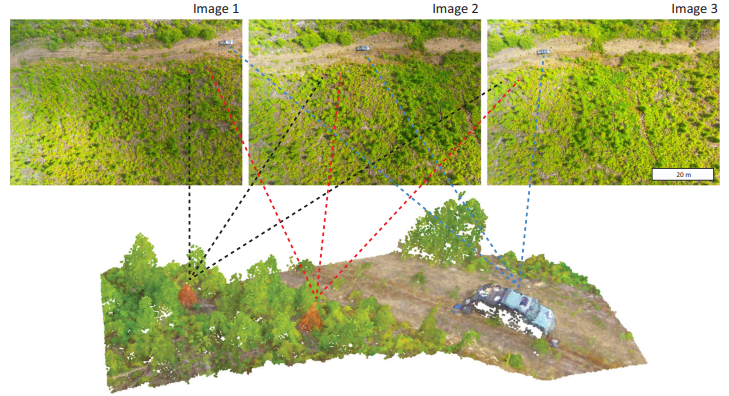
Photogrammetry is a technology to make measurement of a physical object based on various collected images. The position of camera to take images can be used to estimates coordinate (x, y, z) of each pixels in the images. As a result, we can make an estimate of location of each point and reconstruct it into a 3D point cloud.
Different from photogrammetry, LiDAR or laser scanning technology use laser beams to measure the distance of an object. It can examined the surface of the surveyed area and produce accurate x, y, z measurement both in local or global coordinate. The final result of the scanning is a 3D point cloud data of the scanned area containing the coordinate, colour, intensity, normal vectors, and classification value.
Aerial Photogrammetry for Forest Inventory
The use of Digital Aerial Photogrammetry (DAP) is getting more attention for forest industry nowadays. There are many study about the usage of aerial photogrammetry data that has comparable accuracy compared with Airborne Laser Scanning (ALS). The application of DAP is not only subjected to small area of forest (a few to several hundred km2). Currently, a large area of forest (thousand km2) with heterogeneous types of vegetation can employ the usage of aerial photogrammetry to extract different information for forest management.
Information Extracted from Aerial Photogrammetry for Forest Management
We can extract some information from DAP data such as:
Calculation of Timber Volume (m3/ha) [1]
Timber volume refers to the amount of wood in standing trees. It typically measured in units such as cubic meters or cubic feet per hectare. It is a crucial metric in forestry management and represents the potential yield of timber that can be harvested from a given area of forest. Timber volume estimation involves assessing the total volume of wood in trees, including both the main stem (bole) and branches. This information is essential for planning sustainable forestry practices, such as harvesting operations, determining timber supply, and assessing forest productivity.
Calculation of Biomass (ton/ha) [1] [4]
Biomass in the context of forestry refers to the total amount of living organic matter (biological material) present in trees and other vegetation within a specific area. This includes not only the above-ground components such as stems, branches, leaves, and fruits but also below-ground components such as roots. We typically measure biomass in units such as tonnes per hectare. Estimating biomass provides valuable insights into the carbon storage capacity of forests, as trees and vegetation act as carbon sinks by sequestering carbon dioxide from the atmosphere through the process of photosynthesis. Understanding biomass distribution and dynamics is crucial for assessing ecosystem health, carbon accounting, and monitoring changes in forest structure over time.
Calculation of Basal Area (m2/ha) [1]
Basal area represents the cross-sectional area of tree stems at breast height (usually 1.3 meters above ground level) within a defined area of forest, typically expressed in square meters per hectare. It is calculated by summing the cross-sectional areas of all tree stems within a plot or stand. Basal area is one of a fundamental metric that we need to quantify forest stand density and tree competition. It provides insights into the amount of space occupied by tree stems within a given area. It also helps forest managers assess stand structure, growth potential, and forest productivity. Basal area measurements are often used in conjunction with other forest parameters to inform silvicultural practices, such as thinning operations and regeneration planning, to achieve desired forest management objectives.
Calculation of Height [5]
Calculation of height refers to the process of determining the vertical elevation or distance of objects from a reference point or surface. The calculation of height involves estimating the elevation of vegetation elements such as trees within a forested area.
Characterize Forest Canopy Structure [3] [4]
Characterizing forest canopy structure involves describing the arrangement, composition, and spatial distribution of vegetation within the forest canopy. Some factors such as species composition, tree density, canopy cover, and topography can influence the forest canopy structure. Understanding canopy structure is essential for assessing forest health, biodiversity, and ecosystem functioning.
Data Processing
The process of extracting data from Digital Aerial Photogrammetry (DAP) involves several stages:
Data Acquisition
This stage involves planning and executing aerial surveys using digital aerial photogrammetry techniques. Flight planning is crucial to optimize the cost-effectiveness of the survey while ensuring adequate coverage and resolution for the desired applications.
Point Cloud Generation
After data acquisition, we generate point clouds from the collected aerial imagery. Point clouds represent 3D coordinates of points on objects or surfaces in the surveyed area. This step involves processing the aerial imagery to derive the spatial information needed for subsequent analysis.
Photogrammetric Processing
We use various photogrammetric processes to the point cloud data. These processes include image alignment to ensure accurate registration of images, building mesh models to represent the 3D geometry of objects, generating Digital Elevation Models (DEMs) to depict terrain elevations, and guided marker positioning for accurate georeferencing. We need to use different photogrammetry process depend on the data that we want to extract.
Point Cloud Processing
The generated point cloud data undergoes additional processing to enhance its quality and suitability for analysis. This may involve operations such as tiling to divide the point cloud into manageable sections, noise filtering to remove irrelevant or erroneous points, merging Airborne Laser Scanning (ALS) ground points to create a Digital Terrain Model (DTM), normalization to ensure consistent scale and orientation, and generating various metrics to characterize the point cloud data.
Image-Matching Algorithms
Image-matching algorithms can be used to generate point clouds from the aerial imagery. We can categorize these algorithms into feature-based and area-based methods. Feature-based methods use cartographic points and lines to identify matching features in images. Meanwhile area-based methods analyze pixel differences using a moving window approach to identify matching points. These algorithms play a crucial role in accurately reconstructing 3D structures from 2D aerial imagery.
Calculation of Parameters
Once the processed point cloud data is available, we can calculate various parameters related to the surveyed area. These parameters may include geometric properties such as heights, volumes, and areas, as well as structural attributes of vegetation and timber. The calculation of these parameters enables quantitative analysis and assessment of the surveyed area for different applications.
In summary, the process of extracting data from Digital Aerial Photogrammetry involves a series of stages. It includes encompassing data acquisition, point cloud generation, photogrammetric processing, point cloud processing, application of image-matching algorithms, and calculation of parameters. Each stage plays a crucial role in producing accurate and actionable information from aerial imagery for various applications.
Estimating Forest Structural Attributes using UAV-LiDAR
Understanding and managing forests is crucial for sustainable forest management and studying their role in storing carbon globally. The use of Unmanned Aerial Vehicle-Light Detecting and Ranging (UAV-LiDAR) technology has emerged as a promising method for forest management. It offers highly accurate three-dimensional (3D) information about forests at a lower cost and can acquired larger area than mobile mapper LiDAR.
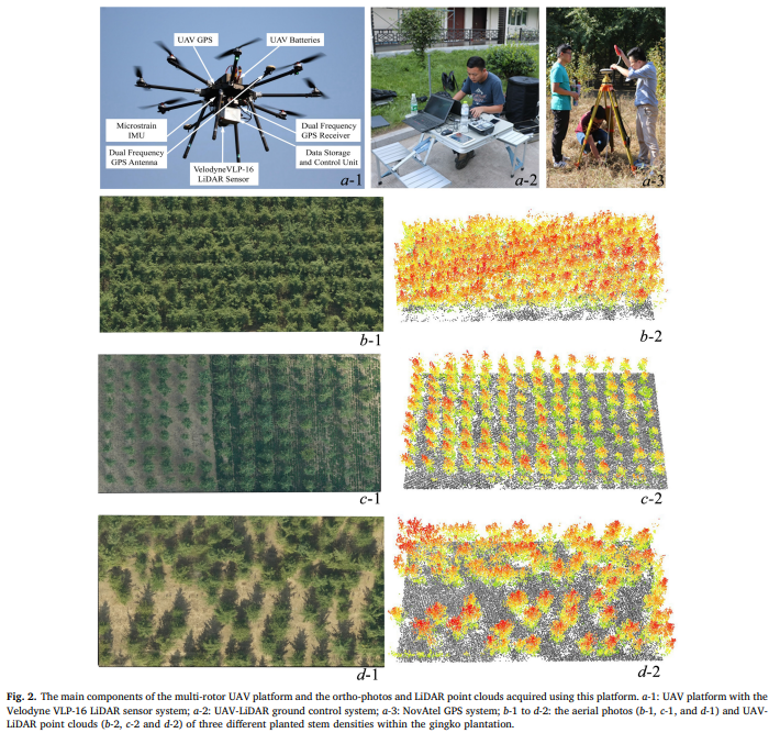
By using parametric (like partial least squares) and non-parametric (like k-Nearest Neighbors and Random Forest) approaches, this study tried to create models for estimation of the structural plant attributes.
Data Extracted from UAV-LiDAR for Forest Structural Attributes
Diameter at Breast Height (DBH)
Diameter at Breast Height, measured in centimeters. DBH is a standard forestry measurement taken at 1.3 meters above the ground level on the main stem of a tree. People use DB as an indicator of tree size and is often correlated with tree age and growth rate.
Lorey’s Height (m)
Lorey’s height is the average height of trees within a given area. It measured from the ground level to the highest point of the canopy. It provides information about the vertical structure of the forest and is useful for assessing tree growth and canopy development. In this study, he partial least squares showed high accuracy in predicting Lorey’s mean height
Stem Density
Stem density refers to the number of tree stems or individuals per unit area, typically measured in square meters. It indicates the density or concentration of trees within a forest stand and is important for assessing forest health, competition, and regeneration potential.
Basal Area (m2/ha)
Basal area is the cross-sectional area of tree stems at breast height per unit area. It usually expressed in square meters per hectare. It provides an indication of the amount of space occupied by tree stems within a forest stand and is commonly used to estimate stand productivity and tree biomass.
Volume (m3/ha )
Volume represents the total wood volume of trees per unit area. It measured in cubic meters per hectare. It reflects the amount of timber or biomass present in a forest stand and is a key parameter for forest inventory, timber harvesting, and carbon stock estimation.
WAGB (Mg/ha)
Aboveground Biomass (WAGB) is the total dry weight of living vegetation above the ground level per unit area. It usually expressed in megagrams (or metric tons) per hectare. The WAGB calculation includes the biomass of tree stems, branches, foliage, and other aboveground plant components. It is an important indicator of forest carbon storage and ecosystem productivity.
These variables collectively provide essential information about the structure, composition, and productivity of forest ecosystems. This information enables forest managers, researchers, and policymakers to make informed decisions regarding forest management, conservation, and sustainable use of forest resources. This study demonstrates the effectiveness of UAV-LiDAR technology in estimating forest attributes. It provides valuable insights for sustainable forest management and carbon storage assessments.
Category List
- 3D Point Cloud
- Artificial Intelligence
- Asset Management
- Digital Twin
- Featured
- Hardware
- Knowledge Graph
- LiDAR
- News
- Site Monitoring
- Vegetation Monitoring
- Virtual Reality
Recent Post
- Digital Twin for Construction Projects – How LiDAR Powers Real-Time Site Models
- Road Asset Management Sydney
- Pavement Condition Survey: AI-Powered Road Assessment for Local Councils
- LiDAR Road Survey Sydney: Mobile Scanning for Councils and Transport Authorities
- Geospatial AI for Infrastructure: How GeoAI Is Transforming Australia’s Road Networks
Reference
[1] Johannes Rahlf, Johannes Breidenbach, Svein Solberg, Erik Næsset, Rasmus Astrup, Digital aerial photogrammetry can efficiently support large-area forest inventories in Norway, Forestry: An International Journal of Forest Research, Volume 90, Issue 5, December 2017, Pages 710–718, https://doi.org/10.1093/forestry/cpx027
[2] Kun Liu, Xin Shen, Lin Cao, Guibin Wang, Fuliang Cao, Estimating forest structural attributes using UAV-LiDAR data in Ginkgo plantations, ISPRS Journal of Photogrammetry and Remote Sensing, Volume 146, 2018, Pages 465-482, ISSN 0924-2716, https://doi.org/10.1016/j.isprsjprs.2018.11.001.
[3] Jayathunga, S., Owari, T., Tsuyuki, S., & Hirata, Y. (2020). Potential of UAV photogrammetry for characterization of forest canopy structure in uneven-aged mixed conifer–broadleaf forests. International Journal of Remote Sensing, 41(1), 53–73. https://doi.org/10.1080/01431161.2019.1648900
[4] Jayathunga, S.; Owari, T.; Tsuyuki, S. Digital Aerial Photogrammetry for Uneven-Aged Forest Management: Assessing the Potential to Reconstruct Canopy Structure and Estimate Living Biomass. Remote Sens. 2019, 11, 338. https://doi.org/10.3390/rs11030338
[5] Goodbody, T.R.H., Coops, N.C. & White, J.C. Digital Aerial Photogrammetry for Updating Area-Based Forest Inventories: A Review of Opportunities, Challenges, and Future Directions. Curr Forestry Rep 5, 55–75 (2019). https://doi.org/10.1007/s40725-019-00087-2