How GeoAI Create Digital Twin in Construction: A Step-by-Step Process
Steps to create digital twin for construction projects required a complex process that involves advanced tools and expert knowledge. GeoAI’s 3D digital twin is crafted with precision and efficiency. This is to ensure that all stakeholders have easy access to accurate and up-to-date information about the project. This article will walk through the key steps involved in creating a digital twin for construction using GeoAI’s cutting-edge tools and techniques.
Step 1: Data Acquisition with Advanced Surveying Tools
The foundation of any digital twin in construction begins with accurate data acquisition. GeoAI’s certified surveyors employ a variety of tools to gather detailed information about the construction site. These tools include:
- Drone-Based LiDAR: This technology allows for the capture of high-resolution 3D data from the air to provide a comprehensive view of the entire site.
- Ground-Based LiDAR: Used for capturing precise details from ground level. It is to ensure that there is no part of the site is overlooked.
- High-Resolution Cameras: These cameras capture sharp and detailed images. This data is essential for accurate photogrammetry and visual analysis.
- 360 Cameras for Panoramic Views: These cameras provide immersive panoramic views. It offers a complete 360 panoramic visual context of the site.
These tools work together to create a detailed and accurate representation of the construction project, laying the groundwork for the digital twin.
Step 2: Data Processing and Reconstruction
Once we finish the data collection, GeoAI’s engineers step in to process and reconstruct the construction project. Photogrammetry is the primary technology we use in this stage. This method allows for the creation of both 2D and 3D models with high accuracy and efficiency. Photogrammetry involves stitching together thousands of images to form a cohesive and detailed digital representation of the site. This method ensures that the digital twin is not only visually accurate but also precise in its measurements and dimensions.
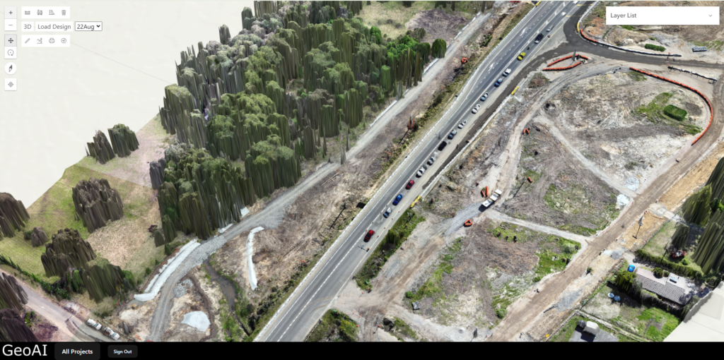
Step 3: Uploading to the Viewer Website
After the reconstruction process is complete, the next step is to upload the data into GeoAI’s viewer website. We design this platform to provide easy access to the digital twin for all stakeholders involved in the project. By hosting the digital twin on an accessible online platform, GeoAI ensures that project managers, engineers, architects, and other stakeholders can interact with the data in real-time, enabling better decision-making and collaboration.
Step 4: Real-Time Updates
One of the key advantages of GeoAI’s process is the speed and near real time updates. From data acquisition to having the digital twin ready for viewing on the website, the entire process takes only about 3 to 4 hours. This quick turnaround time is crucial for maintaining real-time updates on the project, ensuring that stakeholders have the most current information available at all times.
GeoAI’s certified surveyors and engineers work together to collect, process, and upload data efficiently, resulting in a highly accurate and accessible digital twin. With a total processing time of just a few hours, GeoAI ensures that your construction project is always up-to-date, providing real-time insights that are essential for successful project management.
Category List
- 3D Point Cloud
- Artificial Intelligence
- Asset Management
- Digital Twin
- Featured
- Hardware
- Knowledge Graph
- LiDAR
- News
- Site Monitoring
- Vegetation Monitoring
- Virtual Reality
Recent Post
- As-Built Drawing Survey Sydney: LiDAR Verification for Construction Projects
- Digital Twin for Construction Projects – How LiDAR Powers Real-Time Site Models
- Road Asset Management Sydney
- Pavement Condition Survey: AI-Powered Road Assessment for Local Councils
- LiDAR Road Survey Sydney: Mobile Scanning for Councils and Transport Authorities