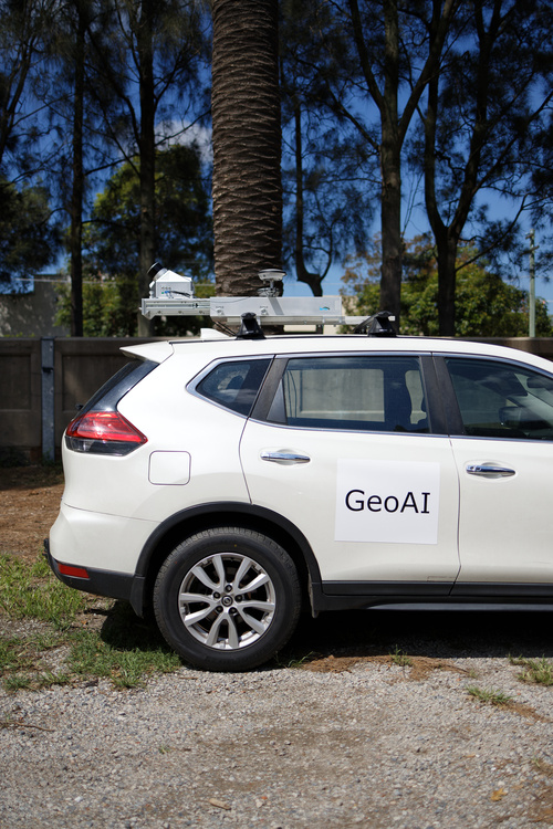
Vehicle Mounted LiDAR
Vehicle mounted Light Detection and Ranging (LiDAR) offer a cost-effective solution of data collection in area where aerial vehicle is impossible to reach such as around airport. Moreover, in the middle of modern transportation and infrastructure development, accurate and efficient mapping of roads and surrounding features is essential. It is a solution to traditional methods of data collection that often prove time-consuming and labor-intensive.
The integrated vehicle mount design allows for installation in different vehicle types. As a result, it becomes more versatile and robust. It is also engineered to withstand harsh operating conditions, including vibrations, temperature variations, and exposure to dust and moisture. Their robust construction ensures reliable performance even in challenging environments over extended periods.
Characteristic of Vehicle Mounted LiDAR
Vehicle-mounted LiDAR systems have several key characteristics that make them essential tools for various applications. It ranges from autonomous driving to infrastructure management. Here are some of the key characteristics of the vehicle mounted LiDAR.
High Precision and Accuracy
Vehicle-mounted LiDAR systems offer high precision and accuracy in capturing three-dimensional data of the surrounding environment. By emitting laser pulses and measuring the time it takes for them to return after hitting objects, LiDAR sensors can create detailed point clouds with precise spatial information.
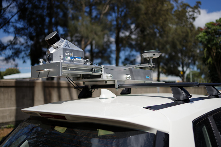
360-Degree Coverage
Many vehicle-mounted LiDAR systems are equipped with rotating or multi-beam camera that provide a 360-degree field of view. This comprehensive coverage ensures that no part of the environment is left unscanned. It allows for thorough mapping and analysis.
Real-Time Data Acquisition
With advancements in LiDAR technology, some vehicle-mounted systems are capable of real-time data acquisition. It enables instant feedback and decision-making in applications such as autonomous driving and navigation.
Long Range and High Density
Modern vehicle-mounted LiDAR systems can detect objects at long ranges while maintaining high point density. This capability is crucial for detecting distant obstacles, accurately delineating road features, and capturing fine details in the environment.
Integration with Other Sensors
Vehicle-mounted LiDAR systems are often offer integration with other sensors such as cameras, GPS, inertial measurement units (IMUs), and radar. This sensor fusion approach enhances the system’s capabilities by providing complementary data streams for improved object detection, localization, and mapping.
Scalability and Modular Design
Many vehicle-mounted LiDAR systems feature a modular design that allows for scalability and customization according to specific application requirements. Users can integrate additional sensors, change mounting configurations, or upgrade hardware components to adapt to evolving needs.
Compliance with Industry Standards
Vehicle-mounted LiDAR systems adhere to industry standards and regulations governing data quality, accuracy, and safety. Manufacturers conduct rigorous testing and certification processes to ensure compliance with applicable standards and guidelines.
Application of Mobile LiDAR
GeoAI use mobile-mounted LiDAR systems for applications across various industries and fields. Their ability to capture detailed three-dimensional data of the surrounding environment while on the move is important for different applications. Some of the key applications include:
Autonomous Vehicles (AVs) and Advanced Driver-Assistance Systems (ADAS)
Mobile-mounted LiDAR is integral to the development and deployment of autonomous vehicles and ADAS technologies. LiDAR sensors provide real-time, high-resolution 3D mapping of the vehicle’s surroundings. As a result, it enables accurate perception of obstacles, pedestrians, road signs, and lane markings for safe navigation and decision-making.
Urban Planning and Infrastructure Management
Mobile LiDAR scanning facilitates rapid and efficient mapping of urban environments. The data generated usually used for urban planning, infrastructure design, and maintenance purposes. It helps in creating detailed digital terrain models (DTMs), detecting changes in infrastructure, assessing road conditions, and optimizing traffic flow.
Road and Highway Asset Surveys
Road authority use Mobile-mounted LiDAR systems for conducting comprehensive surveys of roads, highways, and transportation networks. They enable accurate measurement of road geometry, identification of pavement defects, assessment of roadside features. It can assist in creation of as-built documentation for construction and maintenance projects as well.
Railway and Transportation Infrastructure
Transportation department use Mobile LiDAR scanning for assessing railway tracks, bridges, tunnels, and other transportation infrastructure. It aids in detecting track deformations, monitoring clearance profiles, identifying encroachments, and evaluating structural integrity to ensure safe and efficient operation of railway networks.
Forestry and Environmental Monitoring
Environmental department use Mobile LiDAR technology for forestry management, environmental monitoring, and natural resource assessment. It enables the estimation of forest canopy height, density, and biomass, identification of tree species, mapping of land cover types, and monitoring of ecosystem health and biodiversity.
Emergency Response and Disaster Management
Mobile-mounted LiDAR systems support emergency response efforts and disaster management by rapidly capturing detailed 3D data of disaster-affected areas. They facilitate damage assessment, search and rescue operations, evacuation planning, and infrastructure rehabilitation following natural disasters such as earthquakes, floods, and wildfires.
Utility and Infrastructure Mapping
Mobile LiDAR scanning is employed for mapping utility infrastructure, including power lines, pipelines, telecommunications networks, and underground utilities. It aids in identifying potential hazards, assessing asset condition, planning maintenance activities, and minimizing service disruptions.
Cultural Heritage Documentation
Mobile-mounted LiDAR systems are utilized for documenting cultural heritage sites, archaeological landscapes, and historical monuments. They enable the creation of highly accurate digital reconstructions, preservation of cultural assets, virtual museum exhibits, and heritage site management.
Mining and Quarrying
Mining and quarrying industry use Mobile LiDAR scanning for terrain modeling, volumetric analysis, slope stability assessment, and resource exploration. It aids in optimizing mine planning, monitoring stockpile inventories, and ensuring workplace safety.
Surveying and Mapping
Mobile-mounted LiDAR systems serve as valuable tools for land surveying, topographic mapping, cadastral mapping, and geospatial data collection. They enable efficient data acquisition over large areas, high-density point cloud generation, and creation of accurate digital elevation models (DEMs) for various surveying applications.
In summary, mobile-mounted LiDAR systems offer a wide range of applications across diverse industries. It contributes to improvement of safety, efficiency, and sustainability in various fields of operation. We can expect that the capabilities and applications of mobile LiDAR to expand further as technology continues to advance. As a result, it drives innovation in spatial data acquisition and analysis.
Related Topics
Category List
- 3D Point Cloud
- Artificial Intelligence
- Asset Management
- Digital Twin
- Featured
- Hardware
- Knowledge Graph
- LiDAR
- News
- Site Monitoring
- Vegetation Monitoring
- Virtual Reality
Recent Post
- Scan-to-BIM Workflow Explained: From LiDAR Point Cloud to BIM Model
- As-Built Drawing Survey Sydney: LiDAR Verification for Construction Projects
- Digital Twin for Construction Projects – How LiDAR Powers Real-Time Site Models
- Road Asset Management Sydney
- Pavement Condition Survey: AI-Powered Road Assessment for Local Councils