Photogrammetry vs Image Processing: What’s the Difference and How Are They Used?
Photogrammetry vs Image Processing
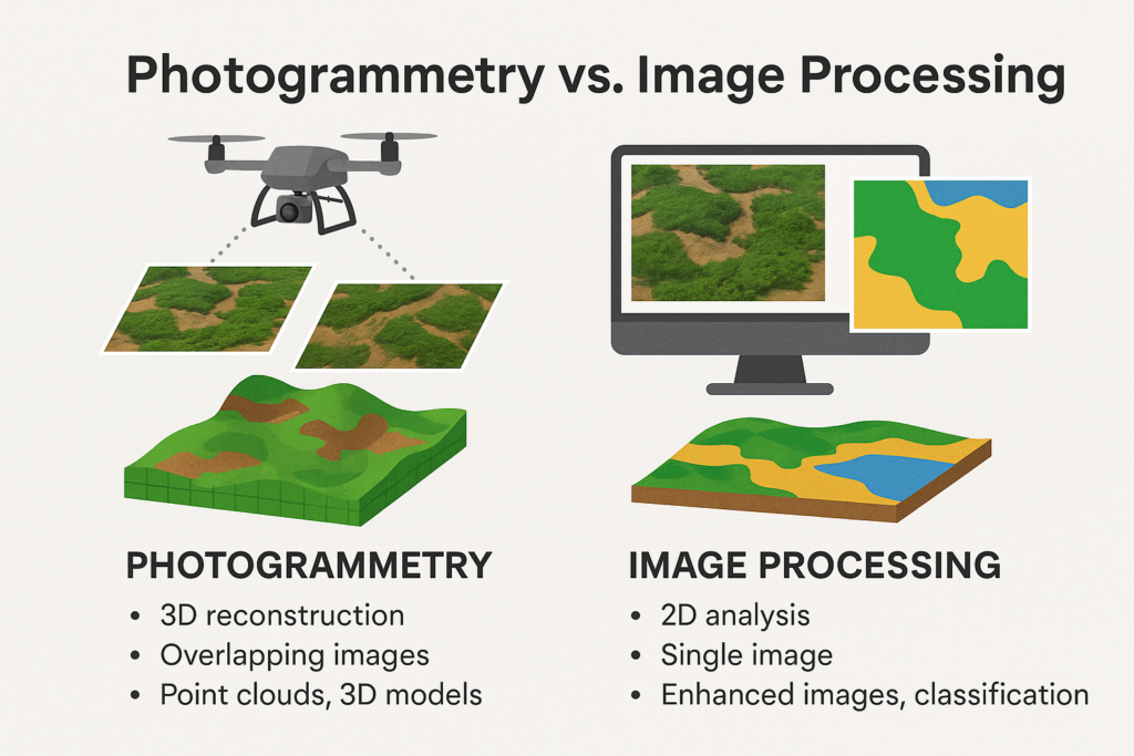
When working with spatial data, understanding the distinction between photogrammetry and image processing is essential. While both methods rely on imagery as input, they serve different purposes in geospatial analysis. This article breaks down the concept of photogrammetry vs image processing, their workflows, applications, and how they complement each other in real-world projects.
What is Photogrammetry?
Photogrammetry is the science of extracting accurate measurements and 3D information from photographs, especially aerial or drone imagery. It is widely used in mapping, construction monitoring, surveying, and creating digital twins. The technique works by analyzing overlapping images taken from different angles to reconstruct a 3D point cloud model or geospatial dataset.
We can categorize photogrammetry based on the device used into:
- Aerial photogrammetry (the data taken from drones or aircraft)
- Terrestrial photogrammetry (the data taken from handheld or tripod cameras)
What is Image Processing?
Image processing refers to the enhancement, correction, or analysis of digital images using algorithms. It includes operations like contrast adjustment, object detection, filtering, classification, and pixel-based analysis. Image processing is crucial for extracting meaningful information from photos, satellite imagery, or any visual data.
Unlike photogrammetry, image processing is not necessarily focused on 3D reconstruction. It is more about interpreting or improving the quality of the image for further analysis.
Step-by-Step: Photogrammetry Workflow
Image Acquisition
- Capture high-resolution overlapping images using drones, UAVs, aircraft, or ground-based cameras.
- Ensure front overlap of 70–80% and side overlap of 60–70% for aerial surveys.
- Include GPS metadata or plan ground control point (GCP) locations for georeferencing.
Camera Calibration
- Apply or estimate intrinsic parameters like focal length, distortion coefficients, and sensor size.
- Use pre-calibrated cameras or software calibration tools to improve model accuracy.
Image Alignment / Structure from Motion (SfM)
- Automatically detect common features (e.g., corners, edges) across overlapping images.
- Estimate camera positions and orientations relative to the scene.
- Create a sparse point cloud representing basic 3D geometry.
Georeferencing
- Use GCPs or RTK/PPK GPS data to align the model with real-world coordinates.
- Improves absolute spatial accuracy for mapping and engineering applications.
Dense Point Cloud Generation
- Generate millions of 3D points using multi-view stereo (MVS) algorithms.
- Captures fine terrain and structure details.
Mesh Reconstruction
- Convert the dense point cloud into a triangulated mesh to form a continuous surface.
- Fill in occluded or less-visible areas for a more complete model.
Texture Mapping
- Project original images onto the mesh to produce photorealistic 3D models.
Orthophoto and DEM/DSM Creation
- Generate georeferenced orthophotos (2D image maps without distortion).
- Extract Digital Elevation Models (bare earth) or Digital Surface Models (including buildings/vegetation).
Export and Visualization
- Export outputs in standard formats (e.g., .LAS, .OBJ, .TIFF, .SHP).
- Visualize in GIS, CAD, or 3D modeling software for further analysis.
Step-by-Step: Image Processing Workflow
Image Acquisition or Input
- Load single or multi-band images from satellites, drones, or RGB/multispectral cameras.
- Optional: collect time-series images for change detection.
Radiometric and Geometric Correction
- Adjust image brightness and remove sensor noise or shadow artifacts.
- Correct image distortions caused by camera angle, lens, or terrain.
Image Enhancement
- Apply filters to sharpen edges, enhance contrast, or reduce noise.
- Normalize pixel values or stretch histograms for visual clarity.
Image Segmentation
- Divide the image into homogeneous regions (e.g., water, vegetation, buildings).
- Techniques include thresholding, edge detection, or object-based segmentation.
Feature Extraction
- Identify specific objects, shapes, or patterns such as roads, vegetation boundaries, or cracks.
- Extract spectral signatures (e.g., NDVI, SAVI) or geometric features.
Classification or Detection
- We usually use machine learning to automated this process
- We can use use supervised (e.g., Support Vector Machines (SVM), Random Forest) or unsupervised (e.g., k-means) algorithms.
- Assign labels to pixels or objects (e.g., forest, water, roof, bare soil).
- Apply deep learning models for advanced detection tasks.
Change Detection (if multi-temporal)
- Compare two or more images over time to assess environmental changes or land development.
Postprocessing and Accuracy Assessment
- Refine classified results using spatial filters or majority voting.
- Validate results using ground truth data or confusion matrices.
Export and Visualization
- Generate thematic maps, export raster/vector files, or integrate into dashboards and GIS systems.
Key Difference between Photogrammetry vs Image Processing
| Feature | Photogrammetry | Image Processing |
| Primary Goal | 3D reconstruction and measurement | 2D image analysis or enhancement |
| Output | Point clouds, orthophotos, 3D models | Enhanced images, object maps, classification |
| Input requirement | Requires overlapping images | Single or multi-band image is enough |
| Accuracy | High spatial accuracy for mapping | Depends on algorithm and sensor quality |
| Use Cases | Mapping, surveying, digital twins | Detection, classification, monitoring changes |
Applications at GeoAI
At GeoAI, we integrate both photogrammetry and image processing to offer end-to-end mapping and analysis solutions. For example:
- We can use photogrammetry to build 3D digital twins of construction sites.
- Image processing detects vegetation, cracks, or water features in imagery.
By combining both methods, we provide accurate, AI-powered geospatial insights tailored to your project needs.
📞 Ready to Get Started?
Let’s discuss how GeoAI can support your project. Contact us today for a free consultation.
📧 admin@geoai.au
🌐 geoai.au
📍 34-36 Byrnes St, Botany NSW 2019
Category List
- 3D Point Cloud
- Artificial Intelligence
- Asset Management
- Digital Twin
- Featured
- Hardware
- Knowledge Graph
- LiDAR
- News
- Site Monitoring
- Vegetation Monitoring
- Virtual Reality
Recent Post
- Pavement Defect Detection with GeoAI: Harnessing Laser Scanners and Profilers
- Asset Inventory Mapping with GeoAI: Complete Road Asset Capture Using Laser Scanning and Profiling
- Mobile Laser Scanner and Laser Profiler: Dual Approach to Road Surface Condition Surveys
- Edge Pavement Detection: Using LiDAR and AI for Road Asset Management
- What is Digital Surface Model (DSM)?