Unlocking the Secrets of Mobile Laser Scanning: Everything You Need to Know
In recent years, mobile laser scanning (MLS) has revolutionized industries that rely on accurate spatial data, from construction and architecture to environmental monitoring and urban planning. This cutting-edge technology offers a fast, efficient, and incredibly detailed way to capture 3D data, but what exactly is mobile laser scanning, and how can it benefit you? In this article, we’ll unlock the secrets of MLS, explore how it works, and discuss its various applications.
What is Mobile Laser Scanning?
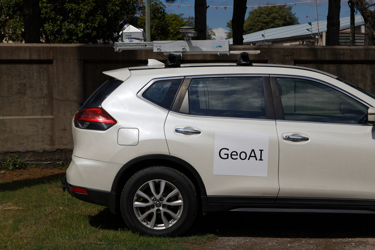
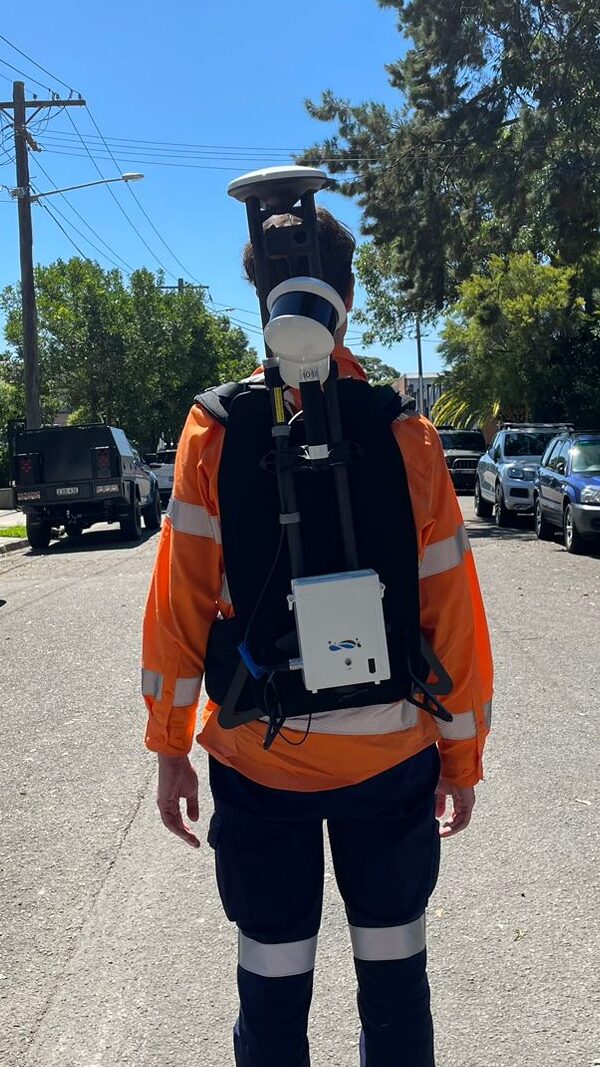
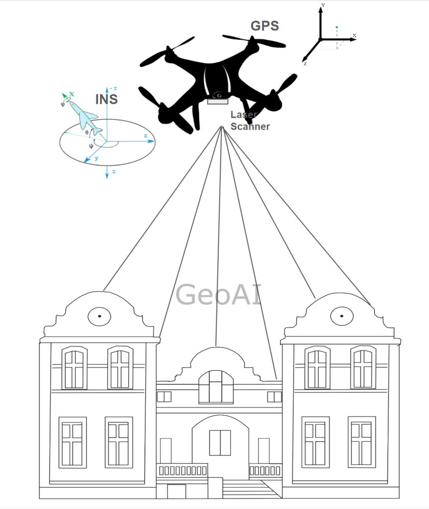
Mobile laser scanning is a technology that uses a laser sensor mounted on a moving vehicle, such as a car, drone, or even a backpack. These lasers emit rapid pulses of light that bounce off surrounding objects and return to the sensor. By measuring the time it takes for each pulse to return, the system can calculate distances and create a highly detailed 3D model of the environment, known as a point cloud.
Unlike traditional stationary laser scanners, MLS offers the advantage of mobility. It has advantage to cover large areas in a fraction of the time based on the type of the vehicle. This makes it ideal for applications where speed, detail, and scalability are key.
How Does Mobile Laser Scanning Work?
Mobile laser scanning involves a few critical components:
- LiDAR Sensor: LiDAR (Light Detection and Ranging) is the main sensor of MLS. It emits laser pulses to measure distances and generate 3D point clouds.
- GNSS/IMU Systems: These provide accurate location and orientation data to ensure that the point cloud is correctly georeferenced.
- Processing Software: After the data is collected, it is processed using specialized software that converts raw point clouds into usable 3D models, maps, or other visualizations.
When mounted on a moving platform, the LiDAR sensor continuously scans its surroundings, capturing millions of data points per second. The GNSS (Global Navigation Satellite System) ensures the precise location of each point, while the IMU (Inertial Measurement Unit) helps account for the movement and tilt of the vehicle.
Key Benefits of Mobile Laser Scanning
- Speed and Efficiency
One of the biggest advantages of MLS is its speed. It can capture vast areas in minutes that would take hours or even days to survey manually. This makes it ideal for large-scale projects, such as mapping cities or highways. The characteristic of each vehicle is different and will impact the speed of the MLS. - High Accuracy
Modern MLS systems can achieve centimeter-level accuracy, making them perfect for applications where precision is crucial. From construction site monitoring to terrain mapping, MLS ensures that you get highly detailed and accurate results. - Versatility
MLS systems can be mounted on various platforms, including vehicles, drones, and even handheld systems. This flexibility allows it to be used in a wide range of environments, from crowded urban areas to remote, rugged terrains. - Reduced Costs
By reducing the time and manpower required for data collection, MLS can significantly lower project costs. The ability to quickly capture and process large datasets means fewer revisits to the site, further cutting expenses. - 3D Visualization
MLS generates highly detailed 3D models that provide a realistic and immersive way to explore data. These models are valuable for urban planners, architects, and engineers who need to visualize complex environments in detail.
Applications of Mobile Laser Scanning
- Construction and Infrastructure: MLS can quickly and accurately capture the current state of construction sites, monitor progress, and ensure that projects are completed to design specifications.
- Transportation: In the transportation industry, MLS is used to map roads, highways, and railways. It enables efficient planning for new infrastructure and helps monitor existing networks for maintenance.
- Urban Planning: City planners use MLS to capture detailed maps of urban environments. This data is essential for managing growth, planning public transportation, and designing new developments.
- Forestry and Environmental Monitoring: MLS can be used to map forests, monitor tree health, and track changes in vegetation over time. It also plays a crucial role in managing natural resources and assessing the impact of environmental changes.
- Mining: In the mining industry, MLS helps create 3D models of open-pit mines and underground tunnels, improving safety and efficiency in operations.
Challenges of Mobile Laser Scanning
While MLS offers many advantages, it is not without its challenges:
- Data Volume: MLS systems generate massive amounts of data. Managing and processing this data requires powerful computing resources and specialized software.
- Initial Costs: The upfront cost of purchasing and deploying MLS systems can be high. However, for large-scale projects, the long-term benefits often outweigh the initial investment.
- Complexity: Interpreting and processing point clouds can be complex, requiring expertise and specialized software. Many companies opt to work with professional service providers to handle this aspect of the process.
The Future of Mobile Laser Scanning
The future of MLS is incredibly promising. Advances in machine learning and AI are making it easier to analyze and interpret point cloud data. Additionally, improvements in LiDAR sensors and GNSS systems are leading to even higher accuracy and faster data collection. As these technologies continue to evolve, we can expect mobile laser scanning to become even more accessible and widely adopted.
Conclusion
Mobile laser scanning is a game-changing technology that provides a fast, accurate, and versatile way to capture 3D data. From construction and transportation to environmental monitoring and urban planning, its applications are vast and varied. As technology continues to improve, MLS will become an increasingly valuable tool for industries that rely on spatial data. Now that you’ve unlocked the secrets of mobile laser scanning, you can explore how it can benefit your next project!
If you’re interested in learning more about how mobile laser scanning can help you or if you’re ready to incorporate this technology into your workflows, get in touch with our team of experts today.
Category List
- 3D Point Cloud
- Artificial Intelligence
- Asset Management
- Digital Twin
- Featured
- Hardware
- Knowledge Graph
- LiDAR
- News
- Site Monitoring
- Vegetation Monitoring
- Virtual Reality
Recent Post
- Pavement Crack Detection using AI and LiDAR
- Pavement Defect Detection with GeoAI: Harnessing Laser Scanners and Profilers
- Asset Inventory Mapping with GeoAI: Complete Road Asset Capture Using Laser Scanning and Profiling
- Mobile Laser Scanner and Laser Profiler: Dual Approach to Road Surface Condition Surveys
- Edge Pavement Detection: Using LiDAR and AI for Road Asset Management